Dolní Loučky | |
|---|---|
.jpg.webp) Aerial view | |
 Flag  Coat of arms | |
 Dolní Loučky Location in the Czech Republic | |
| Coordinates: 49°11′30″N 16°46′17″E / 49.19167°N 16.77139°E | |
| Country | |
| Region | South Moravian |
| District | Brno-Country |
| First mentioned | 1236 |
| Area | |
| • Total | 8.14 km2 (3.14 sq mi) |
| Elevation | 283 m (928 ft) |
| Population (2023-01-01)[1] | |
| • Total | 1,318 |
| • Density | 160/km2 (420/sq mi) |
| Time zone | UTC+1 (CET) |
| • Summer (DST) | UTC+2 (CEST) |
| Postal code | 594 55 |
| Website | www |
Dolní Loučky is a municipality and village in Brno-Country District in the South Moravian Region of the Czech Republic. It has about 1,300 inhabitants.
Dolní Loučky lies approximately 26 kilometres (16 mi) north-west of Brno and 162 km (101 mi) south-east of Prague.
Administrative parts
The village of Střemchoví is an administrative part of Dolní Loučky.
Notable people
- Antonín Mrkos (1918–1996), astronomer
Gallery
 Orlovna (the gymnasium)
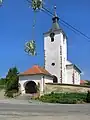 Church of Saint Martin
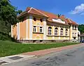
 Old and new school
References
Wikimedia Commons has media related to Dolní Loučky.
This article is issued from Wikipedia. The text is licensed under Creative Commons - Attribution - Sharealike. Additional terms may apply for the media files.