Blousson-Sérian | |
|---|---|
Location of Blousson-Sérian | |
 Blousson-Sérian  Blousson-Sérian | |
| Coordinates: 43°27′39″N 0°11′46″E / 43.4608°N 0.1961°E | |
| Country | France |
| Region | Occitania |
| Department | Gers |
| Arrondissement | Mirande |
| Canton | Pardiac-Rivière-Basse |
| Intercommunality | Bastides et vallons du Gers |
| Government | |
| • Mayor (2020–2026) | Christian Luro[1] |
| Area 1 | 5.27 km2 (2.03 sq mi) |
| Population | 39 |
| • Density | 7.4/km2 (19/sq mi) |
| Time zone | UTC+01:00 (CET) |
| • Summer (DST) | UTC+02:00 (CEST) |
| INSEE/Postal code | 32058 /32230 |
| Elevation | 185–298 m (607–978 ft) (avg. 224 m or 735 ft) |
| 1 French Land Register data, which excludes lakes, ponds, glaciers > 1 km2 (0.386 sq mi or 247 acres) and river estuaries. | |
Blousson-Sérian (French pronunciation: [blusɔ̃ seʁjɑ̃]; Gascon: Blosson e Serian) is a commune in the Gers department in southwestern France.
Geography
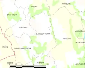
Blousson-Sérian and its surrounding communes
Population
| Year | Pop. | ±% |
|---|---|---|
| 1962 | 94 | — |
| 1968 | 70 | −25.5% |
| 1975 | 63 | −10.0% |
| 1982 | 58 | −7.9% |
| 1990 | 59 | +1.7% |
| 1999 | 50 | −15.3% |
| 2008 | 70 | +40.0% |
See also
References
- ↑ "Répertoire national des élus: les maires" (in French). data.gouv.fr, Plateforme ouverte des données publiques françaises. 13 September 2022.
- ↑ "Populations légales 2020". The National Institute of Statistics and Economic Studies. 29 December 2022.
Wikimedia Commons has media related to Blousson-Sérian.
This article is issued from Wikipedia. The text is licensed under Creative Commons - Attribution - Sharealike. Additional terms may apply for the media files.