Moulins-sur-Tardoire | |
|---|---|
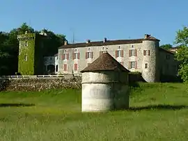 The chateau in Rancogne | |
Location of Moulins-sur-Tardoire | |
 Moulins-sur-Tardoire  Moulins-sur-Tardoire | |
| Coordinates: 45°40′56″N 0°25′15″E / 45.6822°N 0.4208°E | |
| Country | France |
| Region | Nouvelle-Aquitaine |
| Department | Charente |
| Arrondissement | Angoulême |
| Canton | Val de Tardoire |
| Intercommunality | La Rochefoucauld - Porte du Périgord |
| Area 1 | 21.88 km2 (8.45 sq mi) |
| Population | 781 |
| • Density | 36/km2 (92/sq mi) |
| Time zone | UTC+01:00 (CET) |
| • Summer (DST) | UTC+02:00 (CEST) |
| INSEE/Postal code | 16406 /16220 |
| Elevation | 81–138 m (266–453 ft) |
| 1 French Land Register data, which excludes lakes, ponds, glaciers > 1 km2 (0.386 sq mi or 247 acres) and river estuaries. | |
Moulins-sur-Tardoire is a commune in the department of Charente, southwestern France. It was established on 1 January 2019 by merger of the former communes of Vilhonneur (the seat) and Rancogne.[2]
See also
References
Wikimedia Commons has media related to Moulins-sur-Tardoire.
- ↑ "Populations légales 2020". The National Institute of Statistics and Economic Studies. 29 December 2022.
- ↑ Arrêté préfectoral 6 December 2018 (in French)
This article is issued from Wikipedia. The text is licensed under Creative Commons - Attribution - Sharealike. Additional terms may apply for the media files.