Thiouville | |
|---|---|
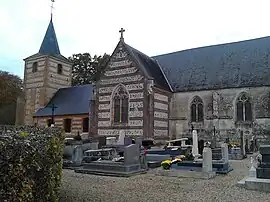 Saint Vaast church in Thiouville | |
.svg.png.webp) Coat of arms | |
Location of Thiouville | |
 Thiouville  Thiouville | |
| Coordinates: 49°41′40″N 0°37′11″E / 49.6944°N 0.6197°E | |
| Country | France |
| Region | Normandy |
| Department | Seine-Maritime |
| Arrondissement | Dieppe |
| Canton | Saint-Valery-en-Caux |
| Intercommunality | CC Côte d'Albâtre |
| Government | |
| • Mayor (2020–2026) | David Anquetil[1] |
| Area 1 | 5.86 km2 (2.26 sq mi) |
| Population | 285 |
| • Density | 49/km2 (130/sq mi) |
| Time zone | UTC+01:00 (CET) |
| • Summer (DST) | UTC+02:00 (CEST) |
| INSEE/Postal code | 76692 /76450 |
| Elevation | 114–140 m (374–459 ft) (avg. 110 m or 360 ft) |
| 1 French Land Register data, which excludes lakes, ponds, glaciers > 1 km2 (0.386 sq mi or 247 acres) and river estuaries. | |
Thiouville is a commune in the Seine-Maritime department in the Normandy region in northern France.
Geography
A farming village in the Pays de Caux, situated some 27 miles (43 km) northeast of Le Havre, at the junction of the D233 and D109 roads.
Population
| Year | Pop. | ±% p.a. |
|---|---|---|
| 1968 | 271 | — |
| 1975 | 257 | −0.75% |
| 1982 | 242 | −0.86% |
| 1990 | 235 | −0.37% |
| 1999 | 240 | +0.23% |
| 2007 | 291 | +2.44% |
| 2012 | 274 | −1.20% |
| 2017 | 309 | +2.43% |
| Source: INSEE[3] | ||
Places of interest
- The church of St. Vaast, dating from the sixteenth century.
- An eighteenth-century chateau.
See also
References
- ↑ Liste des maires du département de la Seine-Maritime, 10 August 2020
- ↑ "Populations légales 2020". The National Institute of Statistics and Economic Studies. 29 December 2022.
- ↑ Population en historique depuis 1968, INSEE
Wikimedia Commons has media related to Thiouville.
This article is issued from Wikipedia. The text is licensed under Creative Commons - Attribution - Sharealike. Additional terms may apply for the media files.