Gerponville | |
|---|---|
 Coat of arms | |
Location of Gerponville | |
 Gerponville  Gerponville | |
| Coordinates: 49°45′10″N 0°33′55″E / 49.7528°N 0.5653°E | |
| Country | France |
| Region | Normandy |
| Department | Seine-Maritime |
| Arrondissement | Le Havre |
| Canton | Fécamp |
| Intercommunality | CA Fécamp Caux Littoral |
| Area 1 | 4.91 km2 (1.90 sq mi) |
| Population | 388 |
| • Density | 79/km2 (200/sq mi) |
| Time zone | UTC+01:00 (CET) |
| • Summer (DST) | UTC+02:00 (CEST) |
| INSEE/Postal code | 76299 /76540 |
| Elevation | 75–132 m (246–433 ft) (avg. 102 m or 335 ft) |
| 1 French Land Register data, which excludes lakes, ponds, glaciers > 1 km2 (0.386 sq mi or 247 acres) and river estuaries. | |
Gerponville is a commune in the Seine-Maritime department in the Normandy region in northern France.
Geography
A farming village situated in the Pays de Caux, some 28 miles (45 km) northeast of Le Havre, near the junction of the D5 and D10 roads.
Heraldry
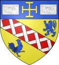
Arms of Gerponville |
The arms of Gerponville are blazoned : Or, a bend gules fretty argent, between a lion and a cock contourny, and on a chief azure, a cross potent Or between 2 banknotes argent.
|
Population
| Year | Pop. | ±% p.a. |
|---|---|---|
| 1968 | 337 | — |
| 1975 | 334 | −0.13% |
| 1982 | 308 | −1.15% |
| 1990 | 330 | +0.87% |
| 1999 | 300 | −1.05% |
| 2007 | 342 | +1.65% |
| 2012 | 390 | +2.66% |
| 2017 | 398 | +0.41% |
| Source: INSEE[2] | ||
Places of interest
- The church of Notre-Dame, dating from the twelfth century.
- The remains of an old manorhouse.
See also
References
Wikimedia Commons has media related to Gerponville.
This article is issued from Wikipedia. The text is licensed under Creative Commons - Attribution - Sharealike. Additional terms may apply for the media files.