Oakridge State Airport | |||||||||||
|---|---|---|---|---|---|---|---|---|---|---|---|
 | |||||||||||
| Summary | |||||||||||
| Airport type | Public | ||||||||||
| Operator | Oregon Department of Aviation | ||||||||||
| Location | Oakridge, Oregon | ||||||||||
| Elevation AMSL | 1,393 ft / 425 m | ||||||||||
| Coordinates | 43°45′09.4440″N 122°30′9.19″W / 43.752623333°N 122.5025528°W | ||||||||||
| Runways | |||||||||||
| |||||||||||
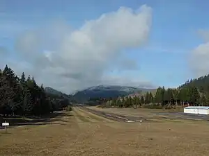
Oakridge State Airport (FAA LID: 5S0) is a public airport located 1 mile (1.6 km) west of Oakridge, in Lane County, Oregon, United States.
Runway
Oakridge Airport has one runway designated 9/27 with an asphalt surface measuring 3610 by 47 feet (1,100 x 14 m).
External links
- City of Oakridge Airport website
- Resources for this airport:
- FAA airport information for 5S0
- AirNav airport information for 5S0
- FlightAware airport information and live flight tracker
- SkyVector aeronautical chart for 5S0
This article is issued from Wikipedia. The text is licensed under Creative Commons - Attribution - Sharealike. Additional terms may apply for the media files.