Navojoa Airport Aeropuerto Nacional de Navojoa | |||||||||||
|---|---|---|---|---|---|---|---|---|---|---|---|
| Summary | |||||||||||
| Airport type | Public | ||||||||||
| Serves | Navojoa, Sonora, Mexico | ||||||||||
| Elevation AMSL | 145 ft / 44 m | ||||||||||
| Coordinates | 26°59′25″N 109°24′58″W / 26.99028°N 109.41611°W | ||||||||||
| Map | |||||||||||
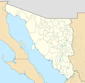 NVJ Location of the airport in Sonora  NVJ NVJ (Mexico) | |||||||||||
| Runways | |||||||||||
| |||||||||||
| Statistics (2019) | |||||||||||
| |||||||||||
Source: Agencia Federal de Aviación Civil[1] | |||||||||||
Navojoa Airport or Navojoa National Airport (Spanish: Aeropuerto Nacional de Navojoa) is a small airport located 5 miles (8 km) south of Navojoa, a city located in the Mayo Valley, in the southern part of the Mexican state of Sonora.
It can be accessed via Sonora State Highway 163.
The airport is used solely for general aviation purposes and, in some occasions, as a race track for street racing competitions.
See also
References
- ↑ "Base de Datos de Aeródromos y Helipuertos". Secretaría de Comunicaciones y Transportes. January 2020. Retrieved April 9, 2020.
External links
This article is issued from Wikipedia. The text is licensed under Creative Commons - Attribution - Sharealike. Additional terms may apply for the media files.