Jamaluddin Rural District
Persian: دهستان جمال الدين | |
|---|---|
 Jamaluddin Rural District | |
| Coordinates: 35°57′39″N 50°37′25″E / 35.96083°N 50.62361°E[1] | |
| Country | Iran |
| Province | Alborz |
| County | Nazarabad |
| District | Central |
| Population (2016)[2] | |
| • Total | 1,443 |
| Time zone | UTC+3:30 (IRST) |
Jamaluddin Rural District (Persian: دهستان جمال الدين) is in the Central District of Nazarabad County, Alborz province, Iran.[3]
In August 2010, Karaj County, Nazarabad County, and Savojbolagh County were separated from Tehran province in the establishment of Alborz province.[4]
At the most recent census of 2016, Jamaluddin Rural District had a population of 1,443 people in 477 households. The largest of its 3 villages was Karkhaneh-e Fakhr-e Iran, with 1,162 people.[2]
References
- ↑ OpenStreetMap contributors (26 March 2023). "Jamaluddin Rural District (Nazarabad County)" (Map). OpenStreetMap. Retrieved 26 March 2023.
- 1 2 "Census of the Islamic Republic of Iran, 1395 (2016)". AMAR (in Persian). The Statistical Center of Iran. p. 30. Archived from the original (Excel) on 28 January 2020. Retrieved 19 December 2022.
- ↑ Davodi, Parviz (19 January 1386). "Approval letter regarding reforms of country divisions in Tehran province". Islamic Parliament Research Center of the Islamic Republic of Iran (in Persian). Ministry of Interior, Political-Defense Commission. Archived from the original on 15 September 2017. Retrieved 11 November 2023.
- ↑ "The establishment law of Alborz province is implemented in the center of Karaj city". BBC (in Persian). Ministry of Interior. 27 August 2010. Archived from the original on 10 November 2023. Retrieved 10 November 2023.
| Capital city | 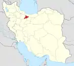 | ||||||||||||
|---|---|---|---|---|---|---|---|---|---|---|---|---|---|
| Counties and cities |
| ||||||||||||
| Sights |
| ||||||||||||
| Populated places | |||||||||||||
| Capital | |||||||||||||||||||
|---|---|---|---|---|---|---|---|---|---|---|---|---|---|---|---|---|---|---|---|
| Districts |
| ||||||||||||||||||
This article is issued from Wikipedia. The text is licensed under Creative Commons - Attribution - Sharealike. Additional terms may apply for the media files.