Asara District
Persian: بخش آسارا | |
|---|---|
 Asara District | |
| Coordinates: 36°01′02″N 51°17′10″E / 36.01722°N 51.28611°E[1] | |
| Country | |
| Province | Alborz |
| County | Karaj |
| Capital | Asara |
| Population (2016)[2] | |
| • Total | 17,150 |
| Time zone | UTC+3:30 (IRST) |
Asara District (Persian: بخش آسارا) is in Karaj County, Alborz province, Iran. Its capital is the city of Asara.
At the 2006 census, its population (as a part of Tehran province) was 18,856, in 5,407 households.[3] The census of 2016 counted 17,150 people in 5,977 households, by which time the county had separated from the province and become a part of recently established Alborz province.[2]
| Administrative Divisions | 2006[3] | 2016[2] | |
|---|---|---|---|
| Adaran RD | 8,995 | 7,679 | |
| Asara RD | 3,780 | 3,063 | |
| Nesa RD | 6,081 | 5,069 | |
| Asara (city) | 1,339 | ||
| Total | 18,856 | 17,150 | |
| RD: Rural District | |||
References
- ↑ OpenStreetMap contributors (25 March 2023). "Asara District (Karaj County)" (Map). OpenStreetMap. Retrieved 25 March 2023.
- 1 2 3 "Census of the Islamic Republic of Iran, 1395 (2016)". AMAR (in Persian). The Statistical Center of Iran. p. 30. Archived from the original (Excel) on 28 January 2020. Retrieved 19 December 2022.
- 1 2 "Census of the Islamic Republic of Iran, 1385 (2006)". AMAR (in Persian). The Statistical Center of Iran. p. 23. Archived from the original (Excel) on 20 September 2011. Retrieved 25 September 2022.
| Capital city | 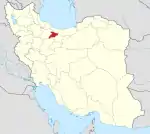 | ||||||||||||
|---|---|---|---|---|---|---|---|---|---|---|---|---|---|
| Counties and cities |
| ||||||||||||
| Sights |
| ||||||||||||
| Populated places | |||||||||||||
| Capital | |||||||||||||||||||||||||
|---|---|---|---|---|---|---|---|---|---|---|---|---|---|---|---|---|---|---|---|---|---|---|---|---|---|
| Districts |
| ||||||||||||||||||||||||
This article is issued from Wikipedia. The text is licensed under Creative Commons - Attribution - Sharealike. Additional terms may apply for the media files.