  | |
| UTC time | 2023-11-10 18:00:56 |
|---|---|
| USGS-ANSS | ComCat |
| Local date | 24 October 2023 (23 days) |
| Magnitude | 5.3 Mw(Largest tremor) |
| Depth | 2-10 km (1.2-6.2 mi) |
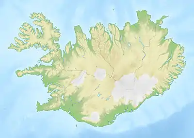
| Epicenter | 63°51′00″N 22°34′44″W / 63.850°N 22.579°W |
| Areas affected | Reykjanes Peninsula, Iceland |
| Max. intensity | VIII (Severe) |
| Casualties | None |
A swarm of intense earthquakes in the Reykjanes Peninsula, Iceland began on 24 October 2023, due to a magmatic intrusion underneath the area.[1] The frequency and intensity of the earthquakes dramatically increased 10 November, with 20,000 tremors recorded by that time, the largest of which exceeded magnitude 5.3. An evacuation was ordered in the town of Grindavík, which is located near the area of the seismic activity.[1] Large-scale subsidence in and around the town is reported to have caused significant damage.
Background
Although earthquakes are a frequent occurrence in Iceland due to the island being situated at the boundary of the Eurasian and North American tectonic plates, the recent swarm was noted for being more extensive than usual.[2] Three volcanic eruptions have occurred in the Reykjanes Peninsula since 2021, around the Fagradalsfjall volcano.[2]
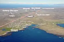
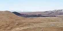
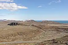
The 2023 earthquake swarm is associated with a magmatic intrusion estimated to be up to 15 kilometers long that runs in a south-westerly direction, starting at Kálfellsheiði [ˈkʰaulˌfɛlsˌheiːðɪ] and following the line of the Sundhnúkur [ˈsʏntˌn̥uːkʏr̥] crater chain at a depth of around 800 meters. The largest of the earthquakes originated under the Sundhnúkur craters but subsequently propagated south-west under Grindavík and into the sea.[3] The town stands on lava erupted from Sundhnúkur around 2,350 years ago.[4] It is one of six communities on the peninsula that are situated on or near an eruptive fissure.[5]
Timeline

The 2023 earthquakes come nearly four years after volcanic activity began near the hyaloclastite mountain Þorbjörn, which indicated that the Reykjanes Peninsula was beginning a new volcanic cycle after 800 years of inactivity.[6] This is the fifth time a magmatic intrusion has formed in the Eldvörp-Svartsengi volcanic system since December of 2019. None of these intrusions have resulted in an eruption.[7] Previous volcanic unrest on the peninsula has mostly been associated with the Fagradalsfjall system, where three out of four confirmed magmatic intrusions have culminated in volcanic eruptions.[8][9][10][1]
October
An earthquake swarm began on the evening of 24 October due to the magmatic intrusion, with the intensity of the earthquakes decreasing by 30 October. Approximately 8,000 earthquakes were detected; most of these tremors occurred at a depth of 2–4 km.[1] The Icelandic Meteorological Office (IMO) reported that the swarm was focused around Svartsengi, north of Grindavík.[11] About 700 earthquakes were recorded earlier in the month, the largest reaching magnitude 3.3.[11]
November
The largest of the earthquakes to date reached magnitude 5.3 on 10 November.[12] By this time, over 22,000 earthquakes had been recorded since the beginning of the swarm in October.[13] The IMO predicted that an eruption was likely, stating that "it will take several days (rather than hours) for magma to reach the surface." The greatest extent of the magma intrusion was inferred to be around the Sundhnúkur crater chain, approximately 3.5 km north of Grindavík. Instruments detected the presence of sulphur dioxide in the atmosphere on 14 November, indicating that magma was now only a few hundred metres under the surface. Although the number of earthquakes decreased somewhat since 10 November, the IMO was still recording between 700–1,000 earthquakes daily by 14 November.[1]
Ground deformation sensors at Festarfjall [ˈfɛstarˌfjatl̥] and Svartsengi recorded that the ground had moved apart by 120 centimetres.[3] Satellite measurements recorded the subsidence by about one metre of a swathe of land measuring approximately five kilometers long and two kilometers wide, running from the Sundhnúkur craters to the western side of Grindavík. The creation of this graben-like formation has enabled scientists to estimate the volume of the magmatic intrusion as approximately 70 million cubic metres.[14] It is estimated that the subsidence has been continuing at a rate of about four centimeters (1.6 inches) a day.[15] A large crack opened up through the town, which old maps indicate is a reactivation of an existing fault. Scientists at the University of Iceland believe that the fault was created by the last Sundhnúkur eruption over 2,000 years ago.[16]
Sensors emplaced in a borehole in Svartsengi detected the presence of sulphur dioxide on 16 November, a classic signature of magma close to the surface. This has led the IMO to conclude that the area around the volcanic edifice of Hagafell, approximately 2 km north of Grindavík, is at the highest level of risk. A rapid 30 mm uplift of the ground in the Svartsengi area was recorded from 18-21 November, likely indicating an upwelling of magma from a source five or more kilometers below the ground.[1] An eruption was still regarded as likely as of 21 November.[1]
Impact on people and property
Grindavík
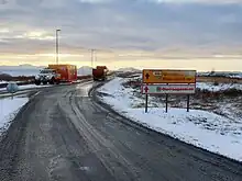
Following the 5.2 tremor on 10 November, a state of emergency was declared, and evacuation plans were put into effect for Grindavík.[17] This culminated in the relocation of nearly 4,000 residents, equivalent to nearly 1 percent of Iceland's entire population.[18] The Icelandic civil protection authority deployed the patrol boat ICGV Þór to the area "for safety purposes".[19] It also closed all roads to Grindavík except for emergency and evacuation purposes.[20] On 13 November, authorities allowed residents to return briefly to the town to retrieve their belongings.[21] Boat owners were also allowed to remove their vessels from the harbour. The Icelandic government is seeking to accommodate displaced residents in holiday homes and little-used properties while the emergency continues. The subsidence, faulting and earthquakes have caused widespread damage to properties and infrastructure in the town.[16] The seismic activity has received significant coverage by the international media.[22] The evacuation of Grindavík has been described as the first community-level evacuation in Iceland since the eruption of Heimaey in 1973.[15]
Blue Lagoon
The management of the Blue Lagoon announced the site's closure to visitors from 9–16 November as a precaution following the earthquakes.[23] Rocks dislodged by the earthquakes were reported to have fallen onto roads in the area while 30 guests left the resort following a 4.8 tremor in the early hours of 9 November.[24] The management later extended the closure through 30 November due to continued seismic activity in the area.[25] In a further response to the ongoing situation, the closure has been extended yet again, now until the 7th of December, to ensure the safety and well-being of both guests and staff amidst the persistent seismic activities.[26]
Svartsengi Power Station
Since the state of emergency was declared, the Svartsengi Power Station has been unoccupied and is being remotely controlled from the Reykjanes Power Station. The management of the power station expects to maintain this remote operation mode until the end of the year. The Reykjanes Power Station is equipped to generate electricity in case the Svartsengi line is cut off. The capability to deliver hot water, a critical function of the Svartsengi Power Station, cannot be replicated by the Reykjanes facility.[27][28]
Barrier construction
A strategic plan for the construction of protective barriers had been established well in advance of the recent seismic disturbances in the area.[8] The commencement of this plan was placed on hold, as there was no pressing threat of a volcanic eruption, coupled with the significant environmental repercussions involved. However, on 10 November, due to escalating earthquake activity, a fleet of lorries began delivering materials to the predetermined site near the Blue Lagoon and Svartsengi Power Station. Yet, this initial operation was soon put on hold owing to concerns about a potential eruption later that same day. The construction process was officially resumed on November 13th, following the Althing's approval of a bill proposed by the Prime Minister.[29] Subsequently, the Minister of Justice began enforcing the new regulations related to the project the next day.[30] Following this, workers have been consistently and vigorously engaged in round-the-clock efforts, efficiently transporting and methodically assembling filler materials at the construction site.[31] In parallel, the civil defense department, equipped with comprehensive plans for more protective barriers, stands ready to extend these protective measures to encompass Grindavík.[32] The Icelandic government has instituted a 0.008% additional property tax, based on the fire insurance value of properties, to fund lava barriers on the Reykjanes peninsula and protect infrastructure from potential eruptions. The temporary tax, planned for three years, could generate nearly ISK 1 billion.[33][34]
See also
References
- 1 2 3 4 5 6 7 "Magma intrusion possibly extending beneath Grindavík". Icelandic Meteorological office. Archived from the original on 11 November 2023. Retrieved 21 November 2023.
- 1 2 Birkebaek, Johannes (27 October 2023). "Iceland hit by thousands of small earthquakes in volcano warning". Reuters. Archived from the original on 5 November 2023. Retrieved 11 November 2023.
- 1 2 "Magma intrusion under Grindavík: eruption likely - LIVE". 10 November 2023. Archived from the original on 13 November 2023. Retrieved 13 November 2023.
- ↑ Jenness, Maria H.; Clifton, Amy E. (17 February 2009). "Controls on the geometry of a Holocene crater row: a field study from southwest Iceland". Bulletin of Volcanology. Springer Science and Business Media LLC. 71 (7): 715–728. Bibcode:2009BVol...71..715J. doi:10.1007/s00445-009-0267-9. ISSN 0258-8900. S2CID 128405263.
- ↑ "Visit Reykjanes - Hopsnes". Archived from the original on 13 November 2023. Retrieved 13 November 2023.
- ↑ Sigfússon, Ingólfur Bjarni; Aðalbjörnsson, Tryggvi; Sigurðardóttir, Kristín; Kolbeinsson, Jóhann Bjarni; Guðmundsson, Ingvar Haukur; Þórisson, Arnar (21 November 2023). "Hamfarir í Grindavík gætu boðað nýjan veruleika á Reykjanesskaga". Kveikur (in Icelandic). Retrieved 23 November 2023.
- ↑ "Litlar hreyfingar mælast innan sigdalsins í og við Grindavík". Veðurstofa Íslands (in Icelandic). Retrieved 23 November 2023.
- 1 2 "Langtímahættumat fyrir Reykjanesskaga vestan Kleifarvatns" (PDF). Íslensk eldfjallasjá (in Icelandic). June 2023. Retrieved 24 November 2023.
- ↑ "Catalogue of Icelandic Volcanoes - Reykjanes". Icelandic Met Office / University of Iceland / Ríkislögreglustjórinn. Archived from the original on 2 November 2023. Retrieved 15 November 2023.
- ↑ "Catalogue of Icelandic Volcanoes - Fagradalsfjall". Icelandic Met Office / University of Iceland / Ríkislögreglustjórinn. Archived from the original on 4 July 2023. Retrieved 15 November 2023.
- 1 2 "Líkur hafa aukist á að nýr kvikugangur myndist undir Fagradalsfjalli". Veðurstofa Íslands (in Icelandic). Archived from the original on 11 November 2023. Retrieved 11 November 2023.
- ↑ National Earthquake Information Center (10 November 2023). "M 5.3 – Iceland region". United States Geological Survey. Archived from the original on 11 November 2023. Retrieved 26 November 2023.
- ↑ Bryant, Miranda (10 November 2023). "Geothermal spa closes in Iceland as guests flee after series of earthquakes". The Guardian. Archived from the original on 13 November 2023. Retrieved 13 November 2023.
- ↑ "Nýjar myndir staðfesta sig upp á allt að einn metra". Visir.is (in Icelandic). 13 November 2023. Archived from the original on 13 November 2023. Retrieved 13 November 2023.
- 1 2 "Iceland volcano: Peninsula faces 'decades' of instability". BBC. 13 November 2023. Archived from the original on 16 November 2023. Retrieved 14 November 2023.
- 1 2 "Óbreytt staða eftir nóttina" (in Icelandic). RÚV. 13 November 2023. Archived from the original on 14 November 2023. Retrieved 14 November 2023.
- ↑ Cappucci, Matthew (10 November 2023). "Evacuations underway in Iceland as possible volcanic eruption looms". The Washington Post. Archived from the original on 11 November 2023. Retrieved 11 November 2023.
- ↑ "Iceland volcano: Emergency declared over volcano Fagradalsfjall eruption concerns". 11 November 2023. Retrieved 29 November 2023.
- ↑ "Iceland declares state of emergency over escalating earthquakes, and volcano eruption fears". Euronews. 10 November 2023. Archived from the original on 11 November 2023. Retrieved 11 November 2023.
- ↑ Durbin, Adam (11 November 2023). "Iceland volcano: Emergency declared over volcano Fagradalsfjall eruption concerns". BBC. Archived from the original on 11 November 2023. Retrieved 12 November 2023.
- ↑ "Residents get brief return to volcano-risk Icelandic town". France 24. 13 November 2023. Archived from the original on 14 November 2023. Retrieved 14 November 2023.
- ↑ "Iceland declares state of emergency over volcanic eruption threat". The Guardian. 10 November 2023. ISSN 0261-3077. Archived from the original on 11 November 2023. Retrieved 11 November 2023.
- ↑ Buckley, Julia (10 November 2023). "Iceland's Blue Lagoon closed as 1,000 earthquakes hit in 24 hours". CNN. Archived from the original on 11 November 2023. Retrieved 11 November 2023.
- ↑ Bjarnason, Egill (10 November 2023). "Iceland's Blue Lagoon spa closes temporarily as earthquakes put area on alert for volcanic eruption". Associated Press. Archived from the original on 9 November 2023. Retrieved 11 November 2023.
- ↑ Tómas, Ragnar (14 November 2023). "Blue Lagoon to Remain Closed Until November 30". Iceland Review. Archived from the original on 15 November 2023. Retrieved 15 November 2023.
- ↑ "Tímabundin lokun framlengd til 7. desember". www.mbl.is (in Icelandic). Retrieved 29 November 2023.
- ↑ Bernharðsdóttir, Oddur Ævar Gunnarsson,Berghildur Erla (16 November 2023). "Orkuverinu í Svartsengi verði fjarstýrt til áramóta - Vísir". visir.is (in Icelandic). Retrieved 29 November 2023.
{{cite web}}: CS1 maint: multiple names: authors list (link) - ↑ "Varaleiðir settar upp og fjarstýring gerð möguleg". www.mbl.is (in Icelandic). Retrieved 30 November 2023.
- ↑ "534/154 stjórnarfrumvarp: vernd mikilvægra innviða á Reykjanesskaga". Alþingi (in Icelandic). Retrieved 29 November 2023.
- ↑ Signýjardóttir, Ástrós; Kristjánsson, Alexander (14 November 2023). "Hægt að hefja framkvæmdir við varnargarða - RÚV.is". RÚV. Retrieved 30 November 2023.
- ↑ "Undirbúningur á fullu við gerð varnargarða". www.mbl.is (in Icelandic). Retrieved 29 November 2023.
- ↑ "Hönnun fleiri varnargarða fyrir Grindavík lokið". www.mbl.is (in Icelandic). Retrieved 29 November 2023.
- ↑ Ćirić, Jelena (13 November 2023). "Iceland's Parliament Proposes Tax to Fund Lava Barriers". Iceland Review. Retrieved 29 November 2023.
- ↑ "Telur landsmenn tilbúna að leggja sitt af mörkum". www.mbl.is (in Icelandic). Retrieved 30 November 2023.
External links
- Icelandic Meteorological Office — Official Website (in Icelandic)
- (in English) Icelandic Meteorological Office — Official Website