| Svartsengi | |
|---|---|
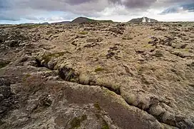 Svartsengi in August 2004 | |
| Highest point | |
| Elevation | 243 m (797 ft)[1] |
| Coordinates | 63°51′50″N 22°26′20″W / 63.86389°N 22.43889°W[1] |
| Naming | |
| English translation | Black meadow |
| Language of name | Icelandic |
| Geography | |
 Svartsengi | |
| Geology | |
| Mountain type | Volcanic system |
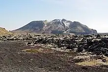
Svartsengi (Icelandic pronunciation: [ˈsvar̥(t)sˌeiɲcɪ]); "black meadow" in Icelandic) is a volcanic system in the southwest of Iceland on the Southern Peninsula, southeast of Keflavík International Airport and north of the town of Grindavík. Made up of fissures, cones and volcanic craters, it has not been very active for several centuries but it became subject to notable seismic activities in 2020, 2022 and 2023 in connection with the nearby Fagradalsfjall.
Geography
Location
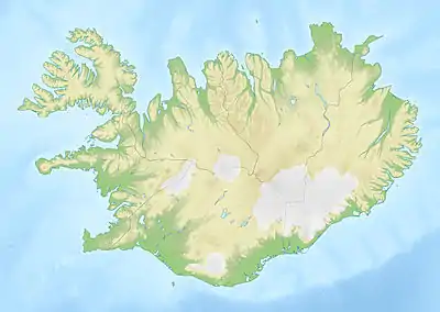
Svartsengi is located in the southwest of Iceland, in the west of the Southern Peninsula, which forms the southwest tip of the country.[1]
The Icelandic toponym Svartsengi, literally "black meadow", designates a small valley at the foot of Sýlingarfell1. From here, the Keflavík and its eponymous international airport are 15 km (9.3 mi) to the northwest, the port city of Vogar is 11 km (6.8 mi) to the north, the port city of Grindavík is 4 km (2.5 mi) to the south, and the cape Reykjanes 16 km (9.9 mi) to the southwest. Reykjavik, the national capital, is about 30 km (19 mi) to the northeast.[1] The Svartsengi Power Station and the Blue Lagoon served by routes 43 and 426 are located on the volcanic system due to the local geothermal context1. At the top of Þorbjörn, the highest point of the Svartsengi, there are relay antennas and to the south, on the edge of the volcano, stand the antennas of the Naval Radio Transmitter Facility Grindavik.
The majority of Svartsengi is located in the municipality of Grindavíkurbær with the exception of the northeastern end of the fissures which are found in that of Vogar, both in the region of Suðurnes.[1]
Geology
Lacking a central volcanic cone, the Svartsengi consists of a set of fissures, cones and volcanic craters aligned over 30 km (19 mi) in length and 7 km (4.3 mi) in width, oriented northeast–southwest and surrounded by fields of lava:[2] Þorbjörn (243 m), Sýlingarfell (206 m), Stóra-Skógfell (188 m) and Litla-Skógfell (85 m) in the southwest to the northeast.[1] Two other volcanic systems surround Svartsengi, which is Reykjanes to the west and Fagradalsfjall to the east,[1] both also consisting of a set of fissures, cones and craters oriented in a parallel manner.[2] Thus, although they have similar geological and topographical characteristics with functioning on the same tectonic principle in a rift context, they also possess notable differences in the geochemical composition of their lavas and a certain individuality in their topography and location, which tends volcanologists to consider them more and more as systems distinct from each other.[2] Together with Reykjanes, Fagradalsfjall, Krýsuvík and Brennisteinsfjöll, Svartsengi is part of the Reykjanes volcanic belt.
The lavas emitted by the Svartsengi are exclusively basalts - notably picrite and tholeite - and are in the form of effusive eruptions with a volcanic explosivity index of 1 to 3 and which produce lava flows and projections limited tephras.[2]
History
%252C_Reykjanes_peninsula.JPG.webp)
During the Holocene, the Svartsengi experienced between twelve and fifteen eruptive periods – a periodicity of approximately 1,000 years – as evidenced by the lava flows associated with it.[2] These recurring activities are represented by a close succession of eruptions over a period of several decades.[2] The last of these eruptions took place in the 13th century with the "Reykjanes fires", a series of effusive eruptions on Svartsengi and Reykjanes which took place between 1210 and 1240 and which produced lava flows with an area of 50 km2 (19 sq mi) for Svartsengi alone.[2]
While the area is usually relatively calm from a geological point of view, intense seismic activity suddenly began on 25 October 2023.[3][4] Several hundred tremors have been detected daily with hypocenters between 6 and 1.5 kilometers deep, the vast majority of magnitude less than 3 but a few exceeding this value, up to 4.5 for the most powerful.[3][4] As of 1 November, 10,000 tremors have already been recorded, including 26 exceeding a magnitude of 3.[3] At the same time, the ground is rising by more than five centimeters, mainly at around 1.5 kilometers to the southwest of the Blue Lagoon and northwest of Þorbjörn.[3][4] These phenomena are interpreted as the intrusion of magma at a depth of four or five kilometers above the sector most affected by soil uplift.[3][4] This seismic activity could constitute the prelude to a volcanic eruption, although such events have already occurred in 2020 and 2022, in the same sector without this leading to an eruption,[4] and the alert level for aviation is reassessed to yellow.[5][6] On 9 November, seismicity reached levels close to 5 on the Richter scale, which led to the decision to close the Blue Lagoon as a precaution.[7]
Activities
The proximity to the most populated cities in the country including Reykjavik and the significant geothermal potential of the site led to the construction of the Svartsengi Power Station, commissioned in 1977. The water discharged near the power plant and heavily loaded with minerals, most notably in silica, form a body of water in the lava field, leading to the construction of the Blue Lagoon in 1992.[8] During the seismic activity of November 2023, work was begun on measures to protect the plant in case of an eruption. This includes substantial protective walls and a diversionary dike.[9]
See also
References
- 1 2 3 4 5 6 7 "Visualisation". Landmælingar Íslands. 13 November 2023.
- 1 2 3 4 5 6 7 "Reykjanes and Svartsengi volcanic systems". Retrieved 2 November 2023.
- 1 2 3 4 5 "Volcanic unrest continues on the Reykjanes Peninsula". Icelandic Meteorological Office. Retrieved 2 November 2023.
- 1 2 3 4 5 "25 October-31 October 2023". volcano.si.edu. Retrieved 2 November 2023.
- ↑ "Importante activité sismique en Islande, potentiel prélude d'une nouvelle éruption volcanique". Le Figaro. 28 October 2023. Retrieved 2 November 2023.
- ↑ "Swarm of earthquakes in Iceland heralds next volcanic eruption". The Guardian. 27 October 2023. Retrieved 2 November 2023.
- ↑ Ari Páll Karlsson (9 November 2023). "Bláa lóninu lokað". ruv.is (in Icelandic). Retrieved 9 November 2023.
- ↑ "L'Islande, Texas de la géothermie" [Iceland , the Texas of Geothermal [technology]]. usinenouvelle.com. 21 November 2013. Retrieved 2 November 2023.
- ↑ Jessica Parker; Nadeem Shad (14 November 2023). "Iceland builds wall to protect power plant from lava". BBC News. Retrieved 14 November 2023.