| Trilling Peaks | |
|---|---|
 | |
| Highest point | |
| Coordinates | 67°58′S 62°45′E / 67.967°S 62.750°E |
Trilling Peaks (67°58′S 62°45′E / 67.967°S 62.750°E) is a group of linear nunataks, comprising three main peaks standing three miles south of South Masson Range in the Framnes Mountains, Mac. Robertson Land. It was mapped by Norwegian cartographers from air photos taken by the Lars Christensen Expedition, 1936-37, and named Trillingnutane (the triplet peaks). Not: Trillingnutane.[1]
Features
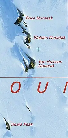
Features include:[2]
Price Nunatak
67°57′S 62°43′E / 67.950°S 62.717°E. Nunatak marking the north end of the Trilling Peaks, 3 miles (4.8 km) south of Mount Burnett in the Framnes Mountains, Mac. Robertson Land. Mapped by Norwegian cartographers from air photos taken by the Lars Christensen Expedition, 1936-37. Named by ANCA for H. Price, senior diesel mechanic at Mawson Station in 1959.[3]
Watson Nunatak
67°58′S 62°45′E / 67.967°S 62.750°E. Nunatak standing between Price and Van Hulssen Nunataks in the Trilling Peaks, Framnes Mountains, in Mac. Robertson Land. Mapped by Norwegian cartographers from air photos taken by the Lars Christensen Expedition, 1936-37. Named by ANCA for K.D. Watson, diesel mechanic at Mawson Station, who assisted in the Framnes Mountains Depot Peak survey by AN ARE in 1965.[4]
Van Hulssen Nunatak
67°59′S 62°45′E / 67.983°S 62.750°E. Nunatak at the south end of the Trilling Peaks in the Framnes Mountains, Mac. Robertson Land. Mapped by Norwegian cartographers from air photos taken by the Lars Christensen Expedition, 1936-37. Named by ANCA for F. Van Hulssen, technical officer (ionosphere) at Mawson Station in 1959.[5]
References
- ↑ Alberts 1995, p. 759.
- ↑ Framnes AADCMap.
- ↑ Alberts 1995, p. 589.
- ↑ Alberts 1995, p. 798.
- ↑ Alberts 1995, p. 776.
Sources
- Alberts, Fred G., ed. (1995), Geographic Names of the Antarctic (PDF) (2 ed.), United States Board on Geographic Names, retrieved 2023-11-07
 This article incorporates public domain material from websites or documents of the United States Board on Geographic Names.
 - Framnes Mountains Satellite Image Map, Australian Antarctic Data Centre, retrieved 2023-11-18