| South Masson Range | |
|---|---|
| Highest point | |
| Elevation | 1,070 m (3,510 ft) |
| Coordinates | 67°53′S 62°47′E / 67.883°S 62.783°E |
| Geography | |
| Location | Antarctica |
| Region | Mac. Robertson Land |
The South Masson Range (67°53′S 62°47′E / 67.883°S 62.783°E) is the southernmost of the three parts into which the Masson Range of theFramnes Mountains, Anatarctica is divided. It rises to 1,070 metres (3,510 ft) and extending 2 miles (3.2 km) in a northeast-southwest arc. The Masson Range was discovered and named by BANZARE, 1929-31, under Mawson. This southern range was mapped by Norwegian cartographers from air photos taken by the Lars Christensen Expedition, 1936-37, and named Sörkammen (the south comb or crest). The approved name, suggested by ANCA in 1960, more clearly identifies the feature as a part of Masson Range. Not: Gora Serkammen, Sörkammen, Sørkammen Crest, South Crest.[1]
Features
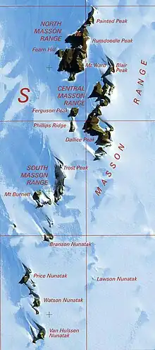
Features include:[2]
Trost Peak
67°52′S 62°48′E / 67.867°S 62.800°E. Peak, 980 metres (3,220 ft), standing 1.5 miles (2.4 km) northeast of Mount Burnett in the Masson Range of the Framnes Mountains. Mapped by Norwegian cartographers from aerial photos taken by the Lars Christensen Expedition, 1936-37. Remapped by ANARE, 1957-60, and named for P.A. Trost, physicist at Mawson Station, 1958.[3]
Mount Burnett
67°53′S 62°45′E / 67.883°S 62.750°E. Peak, 1,050 m, standing 1.5 mi SW of Trost Peak in the Masson Range of the Framnes Mountains. }Mapped by Norwegian cartographers from aerial photos taken by the Lars Christensen Expedition, 1936-37. Remapped by ANARE, 1957-60, and named for Eric Burnett, radiophysicist at Mawson Station, 1958.[4]
Branson Nunatak
67°55′S 62°46′E / 67.917°S 62.767°E. Nunatak between Mount Burnett and Price Nunatak in the Framnes Mountains, Mac. Robertson Land. Mapped by Norwegian cartographers from air photos taken by the Lars Christensen Expedition, 1936-37, and named Horntind (horn peak). Renamed by ANCA for J. Branson, geophysicist at Mawson Station in 1962. Not: Horntind.[5]
Lawson Nunatak
67°56′S 62°51′E / 67.933°S 62.850°E. A small tooth-like nunatak lying 2 miles (3.2 km) southeast of Branson Nunatak in the Masson Range of the Framnes Mountains. The feature was fixed by intersection from trigonometrical stations by ANARE in 1968. Named by ANCA for E.J. Lawson, diesel mechanic at Mawson Station, who assisted with the survey work in 1967.[6]
References
- ↑ Alberts 1995, p. 697.
- ↑ Framnes AADCMap.
- ↑ Alberts 1995, p. 761.
- ↑ Alberts 1995, p. 105.
- ↑ Alberts 1995, p. 89.
- ↑ Alberts 1995, p. 423.
Sources
- Alberts, Fred G., ed. (1995), Geographic Names of the Antarctic (PDF) (2 ed.), United States Board on Geographic Names, retrieved 2023-11-07
 This article incorporates public domain material from websites or documents of the United States Board on Geographic Names.
 - Framnes Mountains Satellite Image Map, Australian Antarctic Data Centre, retrieved 2023-11-18