Saint-Pardoux-les-Cards | |
|---|---|
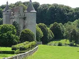 Chateau of Villemonteix | |
Location of Saint-Pardoux-les-Cards | |
 Saint-Pardoux-les-Cards  Saint-Pardoux-les-Cards | |
| Coordinates: 46°05′00″N 2°07′16″E / 46.0833°N 2.1211°E | |
| Country | France |
| Region | Nouvelle-Aquitaine |
| Department | Creuse |
| Arrondissement | Aubusson |
| Canton | Gouzon |
| Intercommunality | CC Marche et Combraille en Aquitaine |
| Government | |
| • Mayor (2020–2026) | Laurent Glomot[1] |
| Area 1 | 24.76 km2 (9.56 sq mi) |
| Population | 285 |
| • Density | 12/km2 (30/sq mi) |
| Time zone | UTC+01:00 (CET) |
| • Summer (DST) | UTC+02:00 (CEST) |
| INSEE/Postal code | 23229 /23150 |
| Elevation | 372–566 m (1,220–1,857 ft) (avg. 394 m or 1,293 ft) |
| 1 French Land Register data, which excludes lakes, ponds, glaciers > 1 km2 (0.386 sq mi or 247 acres) and river estuaries. | |
Saint-Pardoux-les-Cards (French pronunciation: [sɛ̃ paʁdu le kaʁ]; Occitan: Sent Pardós los Cars) is a commune in the Creuse department in central France.
Population
| Year | Pop. | ±% |
|---|---|---|
| 1962 | 461 | — |
| 1968 | 488 | +5.9% |
| 1975 | 449 | −8.0% |
| 1982 | 403 | −10.2% |
| 1990 | 352 | −12.7% |
| 1999 | 298 | −15.3% |
| 2008 | 295 | −1.0% |
See also
References
- ↑ "Répertoire national des élus: les maires". data.gouv.fr, Plateforme ouverte des données publiques françaises (in French). 9 August 2021.
- ↑ "Populations légales 2020". The National Institute of Statistics and Economic Studies. 29 December 2022.
Wikimedia Commons has media related to Saint-Pardoux-les-Cards.
This article is issued from Wikipedia. The text is licensed under Creative Commons - Attribution - Sharealike. Additional terms may apply for the media files.