Ougney-Douvot | |
|---|---|
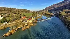 The weir on the river Doubs in Ougney-Douvot | |
Location of Ougney-Douvot | |
 Ougney-Douvot 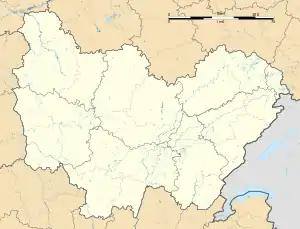 Ougney-Douvot | |
| Coordinates: 47°18′43″N 6°15′32″E / 47.3119°N 6.2589°E | |
| Country | France |
| Region | Bourgogne-Franche-Comté |
| Department | Doubs |
| Arrondissement | Besançon |
| Canton | Baume-les-Dames |
| Government | |
| • Mayor (2020–2026) | Francis Trouillot[1] |
| Area 1 | 6.56 km2 (2.53 sq mi) |
| Population | 254 |
| • Density | 39/km2 (100/sq mi) |
| Time zone | UTC+01:00 (CET) |
| • Summer (DST) | UTC+02:00 (CEST) |
| INSEE/Postal code | 25439 /25640 |
| Elevation | 255–589 m (837–1,932 ft) |
| 1 French Land Register data, which excludes lakes, ponds, glaciers > 1 km2 (0.386 sq mi or 247 acres) and river estuaries. | |
Ougney-Douvot (French pronunciation: [uɲɛ duvo]) is a commune in the Doubs department in the Bourgogne-Franche-Comté region in eastern France.
Population
| Year | Pop. | ±% |
|---|---|---|
| 1962 | 235 | — |
| 1968 | 260 | +10.6% |
| 1975 | 212 | −18.5% |
| 1982 | 168 | −20.8% |
| 1990 | 159 | −5.4% |
| 1999 | 150 | −5.7% |
| 2008 | 183 | +22.0% |
| 2012 | 208 | +13.7% |
See also
References
- ↑ "Répertoire national des élus: les maires". data.gouv.fr, Plateforme ouverte des données publiques françaises (in French). 2 December 2020.
- ↑ "Populations légales 2020". The National Institute of Statistics and Economic Studies. 29 December 2022.
Wikimedia Commons has media related to Ougney-Douvot.
This article is issued from Wikipedia. The text is licensed under Creative Commons - Attribution - Sharealike. Additional terms may apply for the media files.