Ollersdorf im Burgenland | |
|---|---|
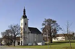 Church of the Assumption of the Virgin Mary | |
 Coat of arms | |
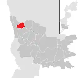 Location within Güssing district | |
 Ollersdorf im Burgenland Location within Burgenland  Ollersdorf im Burgenland Location within Austria | |
| Coordinates: 47°10′N 16°10′E / 47.167°N 16.167°E | |
| Country | Austria |
| State | Burgenland |
| District | Güssing |
| Government | |
| • Mayor | Bernd Strobl (ÖVP) |
| Area | |
| • Total | 8.86 km2 (3.42 sq mi) |
| Population (2018-01-01)[2] | |
| • Total | 933 |
| • Density | 110/km2 (270/sq mi) |
| Time zone | UTC+1 (CET) |
| • Summer (DST) | UTC+2 (CEST) |
| Postal code | 7533 |
| Website | https://www.ollersdorf-burgenland.at/ |
Ollersdorf im Burgenland (Croatian: Fraterovo Selo, Hungarian: Barátfalva) is a town in the district of Güssing in the Austrian state of Burgenland.
Population
| Year | Pop. | ±% |
|---|---|---|
| 1869 | 772 | — |
| 1880 | 858 | +11.1% |
| 1890 | 938 | +9.3% |
| 1900 | 986 | +5.1% |
| 1910 | 968 | −1.8% |
| 1923 | 934 | −3.5% |
| 1934 | 939 | +0.5% |
| 1939 | 924 | −1.6% |
| 1951 | 939 | +1.6% |
| 1961 | 915 | −2.6% |
| 1971 | 1,006 | +9.9% |
| 1981 | 1,015 | +0.9% |
| 1991 | 957 | −5.7% |
| 2001 | 983 | +2.7% |
| 2011 | 975 | −0.8% |
| 2021 | 921 | −5.5% |
References
- ↑ "Dauersiedlungsraum der Gemeinden Politischen Bezirke und Bundesländer - Gebietsstand 1.1.2018". Statistics Austria. Retrieved 10 March 2019.
- ↑ "Einwohnerzahl 1.1.2018 nach Gemeinden mit Status, Gebietsstand 1.1.2018". Statistics Austria. Retrieved 9 March 2019.
This article is issued from Wikipedia. The text is licensed under Creative Commons - Attribution - Sharealike. Additional terms may apply for the media files.