Neuhaus am Klausenbach | |
|---|---|
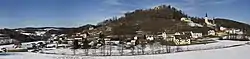 Panoramic view of Neuhaus | |
 Coat of arms | |
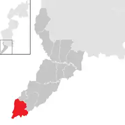 Location within Jennersdorf district | |
 Neuhaus am Klausenbach Location within Austria | |
| Coordinates: 46°52′N 16°2′E / 46.867°N 16.033°E | |
| Country | Austria |
| State | Burgenland |
| District | Jennersdorf |
| Government | |
| • Mayor | Monika Pock (ÖVP) |
| Area | |
| • Total | 19.99 km2 (7.72 sq mi) |
| Elevation | 292 m (958 ft) |
| Population (2018-01-01)[2] | |
| • Total | 921 |
| • Density | 46/km2 (120/sq mi) |
| Time zone | UTC+1 (CET) |
| • Summer (DST) | UTC+2 (CEST) |
| Postal code | 8385 |
| Area code | +43 3329 |
| Website | www.neuhaus-klausenbach.at |
Neuhaus am Klausenbach (Hungarian: Vasdobra, Vas-Dobra, Slovene: Dobra) is a town in the district of Jennersdorf in the Austrian state of Burgenland.
Geography
Cadastral communities are Bonisdorf, Kalch, Krottendorf bei Neuhaus am Klausenbach and Neuhaus am Klausenbach.[3]
Population
| Year | Pop. | ±% |
|---|---|---|
| 1869 | 1,569 | — |
| 1880 | 1,646 | +4.9% |
| 1890 | 1,796 | +9.1% |
| 1900 | 1,728 | −3.8% |
| 1910 | 1,619 | −6.3% |
| 1923 | 1,598 | −1.3% |
| 1934 | 1,604 | +0.4% |
| 1939 | 1,452 | −9.5% |
| 1951 | 1,479 | +1.9% |
| 1961 | 1,428 | −3.4% |
| 1971 | 1,321 | −7.5% |
| 1981 | 1,250 | −5.4% |
| 1991 | 1,163 | −7.0% |
| 2001 | 1,064 | −8.5% |
| 2011 | 933 | −12.3% |
| 2016 | 950 | +1.8% |
References
- ↑ "Dauersiedlungsraum der Gemeinden Politischen Bezirke und Bundesländer - Gebietsstand 1.1.2018". Statistics Austria. Retrieved 10 March 2019.
- ↑ "Einwohnerzahl 1.1.2018 nach Gemeinden mit Status, Gebietsstand 1.1.2018". Statistics Austria. Retrieved 9 March 2019.
- ↑ Katastralgemeindenverzeichnis, www.bev.gv.at
This article is issued from Wikipedia. The text is licensed under Creative Commons - Attribution - Sharealike. Additional terms may apply for the media files.