Königsdorf | |
|---|---|
 Municipal office | |
 Coat of arms | |
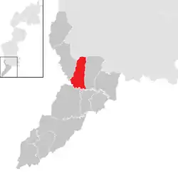 Location within Jennersdorf district | |
 Königsdorf Location within Austria | |
| Coordinates: 47°0′N 16°10′E / 47.000°N 16.167°E | |
| Country | Austria |
| State | Burgenland |
| District | Jennersdorf |
| Government | |
| • Mayor | Mario Trinkl (SPÖ) |
| Area | |
| • Total | 15.67 km2 (6.05 sq mi) |
| Elevation | 236 m (774 ft) |
| Population (2022) | |
| • Total | 768 |
| • Density | 49/km2 (130/sq mi) |
| Time zone | UTC+1 (CET) |
| • Summer (DST) | UTC+2 (CEST) |
| Postal code | 7563 |
| Website | https://www.koenigsdorf.at/ |
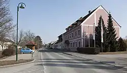
Königsdorf (Hungarian: Királyfalva, Slovene: Kraljevci) is a village in the district of Jennersdorf in the Austrian state of Burgenland. In 2022 the population of the village was 768.
Geography
Königsdorf is located at an altitude of 239m, and is in the valley of the river Lafnitz. The village is 10km to the south-east of Fürstenfeld. Neighbouring settlements include Kukmirn to the north, Eltendorf and Weichselbaum to the east, Jennersdorf to the south and Bad Loipersdorf and Rudersdorf to the west.
Population
| Year | Pop. | ±% |
|---|---|---|
| 1869 | 1,373 | — |
| 1880 | 1,374 | +0.1% |
| 1890 | 1,373 | −0.1% |
| 1900 | 1,226 | −10.7% |
| 1910 | 1,183 | −3.5% |
| 1923 | 1,093 | −7.6% |
| 1934 | 1,100 | +0.6% |
| 1939 | 1,081 | −1.7% |
| 1951 | 882 | −18.4% |
| 1961 | 850 | −3.6% |
| 1971 | 805 | −5.3% |
| 1981 | 895 | +11.2% |
| 1991 | 781 | −12.7% |
| 2001 | 757 | −3.1% |
| 2011 | 711 | −6.1% |
References
- ↑ "Dauersiedlungsraum der Gemeinden Politischen Bezirke und Bundesländer - Gebietsstand 1.1.2018". Statistics Austria. Retrieved 10 March 2019.
This article is issued from Wikipedia. The text is licensed under Creative Commons - Attribution - Sharealike. Additional terms may apply for the media files.