Le Breuil-en-Auge | |
|---|---|
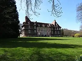 The chateau in Le Breuil-en-Auge | |
Location of Le Breuil-en-Auge | |
 Le Breuil-en-Auge  Le Breuil-en-Auge | |
| Coordinates: 49°13′40″N 0°13′37″E / 49.2278°N 0.2269°E | |
| Country | France |
| Region | Normandy |
| Department | Calvados |
| Arrondissement | Lisieux |
| Canton | Pont-l'Évêque |
| Government | |
| • Mayor (2020–2026) | David Pottier[1] |
| Area 1 | 9.39 km2 (3.63 sq mi) |
| Population | 994 |
| • Density | 110/km2 (270/sq mi) |
| Time zone | UTC+01:00 (CET) |
| • Summer (DST) | UTC+02:00 (CEST) |
| INSEE/Postal code | 14102 /14130 |
| Elevation | 21–145 m (69–476 ft) (avg. 38 m or 125 ft) |
| 1 French Land Register data, which excludes lakes, ponds, glaciers > 1 km2 (0.386 sq mi or 247 acres) and river estuaries. | |
Le Breuil-en-Auge (French pronunciation: [lə bʁœj ɑ̃.n‿oʒ] ⓘ, literally Le Breuil in Auge) is a commune in the Calvados department in the Normandy region in northwestern France.
Population
| Year | Pop. | ±% |
|---|---|---|
| 1962 | 550 | — |
| 1968 | 599 | +8.9% |
| 1975 | 643 | +7.3% |
| 1982 | 751 | +16.8% |
| 1990 | 779 | +3.7% |
| 1999 | 846 | +8.6% |
| 2008 | 940 | +11.1% |
See also
References
- ↑ "Répertoire national des élus: les maires" (in French). data.gouv.fr, Plateforme ouverte des données publiques françaises. 13 September 2022.
- ↑ "Populations légales 2020". The National Institute of Statistics and Economic Studies. 29 December 2022.
Wikimedia Commons has media related to Le Breuil-en-Auge.
This article is issued from Wikipedia. The text is licensed under Creative Commons - Attribution - Sharealike. Additional terms may apply for the media files.