Lamastre | |
|---|---|
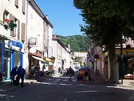 The shopping area in Lamastre | |
.svg.png.webp) Coat of arms | |
Location of Lamastre | |
 Lamastre  Lamastre | |
| Coordinates: 44°59′11″N 4°34′54″E / 44.9864°N 4.5817°E | |
| Country | France |
| Region | Auvergne-Rhône-Alpes |
| Department | Ardèche |
| Arrondissement | Tournon-sur-Rhône |
| Canton | Haut-Vivarais |
| Government | |
| • Mayor (2020–2026) | Jean-Paul Vallon[1] |
| Area 1 | 25.45 km2 (9.83 sq mi) |
| Population | 2,361 |
| • Density | 93/km2 (240/sq mi) |
| Time zone | UTC+01:00 (CET) |
| • Summer (DST) | UTC+02:00 (CEST) |
| INSEE/Postal code | 07129 /07270 |
| Elevation | 342–860 m (1,122–2,822 ft) |
| 1 French Land Register data, which excludes lakes, ponds, glaciers > 1 km2 (0.386 sq mi or 247 acres) and river estuaries. | |
Lamastre (French pronunciation: [lamastʁ]; Occitan: La Mastra) is a commune in the Ardèche department in southern France. It lies on the river Doux. The Chemin de fer du Vivarais, a metre-gauge tourist railway, connects Lamastre with Tournon-sur-Rhône.
Population
|
| ||||||||||||||||||||||||||||||||||||||||||||||||||||||||||||||||||||||||||||||||||||||||||||||||||||||||||||||||||
| Source: EHESS[3] and INSEE (1968-2017)[4] | |||||||||||||||||||||||||||||||||||||||||||||||||||||||||||||||||||||||||||||||||||||||||||||||||||||||||||||||||||
See also
References
- ↑ "Répertoire national des élus: les maires". data.gouv.fr, Plateforme ouverte des données publiques françaises (in French). 2 December 2020.
- ↑ "Populations légales 2020". The National Institute of Statistics and Economic Studies. 29 December 2022.
- ↑ Des villages de Cassini aux communes d'aujourd'hui: Commune data sheet Lamastre, EHESS (in French).
- ↑ Population en historique depuis 1968, INSEE
External links
Wikimedia Commons has media related to Lamastre.
This article is issued from Wikipedia. The text is licensed under Creative Commons - Attribution - Sharealike. Additional terms may apply for the media files.