La Balme-de-Thuy | |
|---|---|
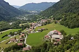 La Balme-de-Thuy, in the valley of Thônes | |
Location of La Balme-de-Thuy | |
 La Balme-de-Thuy  La Balme-de-Thuy | |
| Coordinates: 45°54′05″N 6°16′37″E / 45.9014°N 6.2769°E | |
| Country | France |
| Region | Auvergne-Rhône-Alpes |
| Department | Haute-Savoie |
| Arrondissement | Annecy |
| Canton | Faverges |
| Government | |
| • Mayor (2020–2026) | Pierre Barrucand[1] |
| Area 1 | 17.79 km2 (6.87 sq mi) |
| Population | 451 |
| • Density | 25/km2 (66/sq mi) |
| Time zone | UTC+01:00 (CET) |
| • Summer (DST) | UTC+02:00 (CEST) |
| INSEE/Postal code | 74027 /74230 |
| Elevation | 534–1,915 m (1,752–6,283 ft) |
| 1 French Land Register data, which excludes lakes, ponds, glaciers > 1 km2 (0.386 sq mi or 247 acres) and river estuaries. | |
La Balme-de-Thuy (French pronunciation: [la balm də tɥi]; Arpitan: La Bârma-dè-Tui) is a commune in the Haute-Savoie department in the Auvergne-Rhône-Alpes region in south-eastern France.
Geography
The Fier flows westward through the middle of the commune and forms part of its western border.
See also
References
- ↑ "Répertoire national des élus: les maires" (in French). data.gouv.fr, Plateforme ouverte des données publiques françaises. 13 September 2022.
- ↑ "Populations légales 2020". The National Institute of Statistics and Economic Studies. 29 December 2022.
Wikimedia Commons has media related to La Balme-de-Thuy.
This article is issued from Wikipedia. The text is licensed under Creative Commons - Attribution - Sharealike. Additional terms may apply for the media files.