Héry-sur-Alby | |
|---|---|
 Héry-sur-Alby | |
Location of Héry-sur-Alby | |
 Héry-sur-Alby  Héry-sur-Alby | |
| Coordinates: 45°47′52″N 6°00′50″E / 45.7978°N 6.0139°E | |
| Country | France |
| Region | Auvergne-Rhône-Alpes |
| Department | Haute-Savoie |
| Arrondissement | Annecy |
| Canton | Rumilly |
| Intercommunality | CA Grand Annecy |
| Government | |
| • Mayor (2020–2026) | Jacques Archinard[1] |
| Area 1 | 7.33 km2 (2.83 sq mi) |
| Population | 979 |
| • Density | 130/km2 (350/sq mi) |
| Time zone | UTC+01:00 (CET) |
| • Summer (DST) | UTC+02:00 (CEST) |
| INSEE/Postal code | 74142 /74540 |
| Elevation | 398–702 m (1,306–2,303 ft) |
| 1 French Land Register data, which excludes lakes, ponds, glaciers > 1 km2 (0.386 sq mi or 247 acres) and river estuaries. | |
Héry-sur-Alby (French pronunciation: [eʁi syʁ albi]; literally Héry on Alby;Arpitan: Éri) is a commune in the Haute-Savoie department in the Auvergne-Rhône-Alpes region in south-eastern France.
Geography
The Chéran forms the commune's eastern border.
Gallery
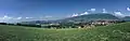 Panorama of the massif des Bornes and Bauges seen from Héry-sur-Alby
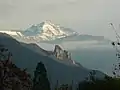 The Trélod, The Montagne du Charbon et the Tours Saint-Jacques seen from Héry-sur-Alby.
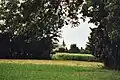 Notre-Dame-de-la-Nativité church in Héry-sur-Alby.
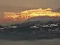 Sunset on the snowy Parmelan, seen from Héry-sur-Alby.
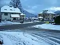 Snowy streets in Héry-sur-Alby.
 The Semnoz seen from a wheat field on top of Héry-sur-Alby's hill.
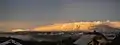 Panorama of the snowy Parmelan and Semnoz seen from Héry-sur-Alby.
See also
References
- ↑ "Répertoire national des élus: les maires" (in French). data.gouv.fr, Plateforme ouverte des données publiques françaises. 13 September 2022.
- ↑ "Populations légales 2020". The National Institute of Statistics and Economic Studies. 29 December 2022.
Wikimedia Commons has media related to Héry-sur-Alby.
This article is issued from Wikipedia. The text is licensed under Creative Commons - Attribution - Sharealike. Additional terms may apply for the media files.