Kirchberg an der Pielach | |
|---|---|
 Coat of arms | |
 Kirchberg an der Pielach Location within Austria | |
| Coordinates: 48°1′N 15°26′E / 48.017°N 15.433°E | |
| Country | Austria |
| State | Lower Austria |
| District | Sankt Pölten-Land |
| Government | |
| • Mayor | Franz Singer |
| Area | |
| • Total | 63.5 km2 (24.5 sq mi) |
| Elevation | 371 m (1,217 ft) |
| Population (2018-01-01)[2] | |
| • Total | 3,225 |
| • Density | 51/km2 (130/sq mi) |
| Time zone | UTC+1 (CET) |
| • Summer (DST) | UTC+2 (CEST) |
| Postal code | 3204 |
| Area code | 02722 |
| Website | http://www.kirchberg-pielach.at |
Kirchberg an der Pielach is a town in the district of Sankt Pölten-Land in the Austrian state of Lower Austria.
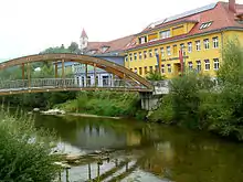
A bridge on the Pielach river, the school and Saint Martin Pfarrkirche in background.
Population
| Year | Pop. | ±% |
|---|---|---|
| 1971 | 2,692 | — |
| 1981 | 2,918 | +8.4% |
| 1991 | 3,197 | +9.6% |
| 2001 | 3,168 | −0.9% |
| 2018 | 3,225 | +1.8% |
| 2019 | 3,221 | −0.1% |
References
- ↑ "Dauersiedlungsraum der Gemeinden Politischen Bezirke und Bundesländer - Gebietsstand 1.1.2018". Statistics Austria. Retrieved 10 March 2019.
- ↑ "Einwohnerzahl 1.1.2018 nach Gemeinden mit Status, Gebietsstand 1.1.2018". Statistics Austria. Retrieved 9 March 2019.
This article is issued from Wikipedia. The text is licensed under Creative Commons - Attribution - Sharealike. Additional terms may apply for the media files.