Königswiesen | |
|---|---|
 | |
 Coat of arms | |
 Königswiesen Location within Austria | |
| Coordinates: 48°24′28″N 14°50′29″E / 48.40778°N 14.84139°E | |
| Country | Austria |
| State | Upper Austria |
| District | Freistadt |
| Government | |
| • Mayor | Johann Holzmann (ÖVP) |
| Area | |
| • Total | 73.41 km2 (28.34 sq mi) |
| Elevation | 614 m (2,014 ft) |
| Population (2018-01-01)[2] | |
| • Total | 3,113 |
| • Density | 42/km2 (110/sq mi) |
| Time zone | UTC+1 (CET) |
| • Summer (DST) | UTC+2 (CEST) |
| Postal code | 4280 |
| Area code | 07955 |
| Vehicle registration | FR |
| Website | www |
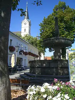
Königswiesen is a municipality in the district of Freistadt in the Austrian state of Upper Austria.
Population
| Year | Pop. | ±% |
|---|---|---|
| 1869 | 2,663 | — |
| 1880 | 2,756 | +3.5% |
| 1890 | 2,692 | −2.3% |
| 1900 | 2,783 | +3.4% |
| 1910 | 2,771 | −0.4% |
| 1923 | 2,707 | −2.3% |
| 1934 | 2,727 | +0.7% |
| 1939 | 2,703 | −0.9% |
| 1951 | 2,717 | +0.5% |
| 1961 | 2,707 | −0.4% |
| 1971 | 2,921 | +7.9% |
| 1981 | 3,057 | +4.7% |
| 1991 | 3,090 | +1.1% |
| 2001 | 3,123 | +1.1% |
References
- ↑ "Dauersiedlungsraum der Gemeinden Politischen Bezirke und Bundesländer - Gebietsstand 1.1.2018". Statistics Austria. Retrieved 10 March 2019.
- ↑ "Einwohnerzahl 1.1.2018 nach Gemeinden mit Status, Gebietsstand 1.1.2018". Statistics Austria. Retrieved 9 March 2019.
Wikimedia Commons has media related to Königswiesen.
This article is issued from Wikipedia. The text is licensed under Creative Commons - Attribution - Sharealike. Additional terms may apply for the media files.