Hrunamannahreppur | |
|---|---|
 Coat of arms | |
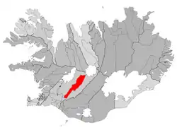 Location of the municipality | |
 Hrunamannahreppur | |
| Coordinates: 64°07′30″N 20°21′29″W / 64.125°N 20.358°W | |
| Country | Iceland |
| Region | Southern Region |
| Constituency | South Constituency |
| Government | |
| • Manager | Jón G. Valgeirsson |
| Area | |
| • Total | 1,375 km2 (531 sq mi) |
| Population | |
| • Total | 785 |
| • Density | 0.57/km2 (1.5/sq mi) |
| Postal code(s) | 845 |
| Municipal number | 8710 |
| Website | fludir |
Hrunamannahreppur (Icelandic pronunciation: [ˈr̥ʏːnaˌmanːaˌr̥ɛhpʏr̥] ⓘ) is a municipality located in Iceland. Its major settlement is Flúðir.
The district abuts the Highlands, so that farmers' livestock occasionally strays there.[1]
Hrunamannahreppur and other parts of southwest Iceland were among the first where biting midges (Ceratopogonidae) were detected after their first appearance in Iceland in 2015.[2]
Localities
References
- ↑ "Farmers find lost sheep in middle of highlands". Iceland Monitor. 2018-01-05. Retrieved 2022-05-12.
- ↑ Vala Hafstað (2022-05-12). "Biting Settlers Seen in Reykjavík". Iceland Monitor. Retrieved 2019-02-15.
This article is issued from Wikipedia. The text is licensed under Creative Commons - Attribution - Sharealike. Additional terms may apply for the media files.