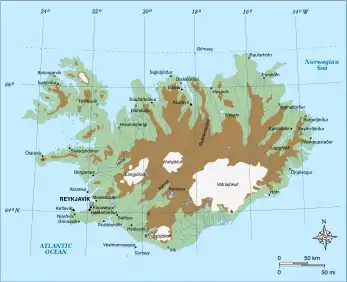
The Highland (Icelandic: Hálendið) or The Central Highland[1] is an area that comprises much of the interior land of Iceland. The Highland is situated above 300–400 meters (1000–1300 feet) and is mostly uninhabitable. The soil is primarily volcanic ash, and the terrain consists of basalt mountains and lava fields. Snow covers the Highland from October until the beginning of June.[2] A few oasis-like areas such as Herðubreiðarlindir and Þórsmörk are also found in the Highland. The Highland has many notable natural features and hiking trails.[3]
Natural features in the Highland
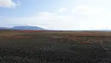
The Highland is made of various geological features, including Landmannalaugar, Torfajökull, Eldgjá, Þórsmörk, Herðubreið, Askja, Hveradalir, Lakagígar, the Fagrifoss waterfall. Sites in the Highland are difficult to access and may be accessible only during summer months. Most sites in the Highland require all-wheel drive or all-terrain vehicles for access, due to unpaved dirt roads. Careful planning is recommended when traveling in the Highland.
Glaciers and volcanoes in the Highland
The largest glaciers in the Highlands are Vatnajökull, Langjökull, Eyjafjallajökull, Mýrdalsjökull and Hofsjökull with multiple runoff outlet glaciers as seen with Vantnajökull glacier connecting to Breiðamerkurjökull outlet and Tungnafellsjökull outlet. Many glaciers occur atop volcanoes, some of which erupt regularly, such as the Bárðabunga volcano and glacier.[4] The most famous of these volcanoes in recent times is Eyjafjallajökull, which erupted in 2010. In the sandy Highland, vegetation is found only at the edges of glaciers and near rivers and creeks that flow through the Highland. There is a pervasive danger of glacial outburst floods, or "glacier runs," at times of eruptions and volcanic activity.
Recreation in the Highland
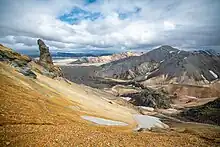
There are several hiking trails in the Highland. A popular trail is the 54 km Laugavegur hiking trail from Landmannalaugar to Þórsmörk. Other notable hikes are Fimmvörðuháls and old Kjalvegur. Some trails cross glaciers and rivers.
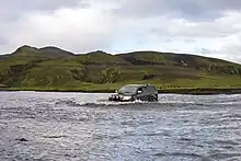
Highland roads or F-Roads
The Highland can be crossed only during the Icelandic summer.[5] For the rest of the year, Highland roads are closed. Driving off-road is forbidden,[6] to protect both drivers and environmental features.
The best-known Highland roads are Kaldidalur, Kjölur, Kjalvegur, Fjallabak syðri, Fjallabak nyrðri, Lakavegur, Kverkfjöll, and Sprengisandur. Most Highland roads require four-wheel drive vehicles, which also assist in crossing rivers. However, the Kjölur route can be traversed easily in an ordinary car and is therefore one of the more popular Highland roads.
See also
References
- ↑ Bishop, Michaël Virgil; Ólafsdóttir, Rannveig; Árnason, Þorvarður (February 2022). "Tourism, Recreation and Wilderness: Public Perceptions of Conservation and Access in the Central Highland of Iceland". Land. 11 (2): 242. doi:10.3390/land11020242. ISSN 2073-445X.
- ↑ "Weather and climate in Iceland". www.visiticeland.com. Retrieved 2023-09-06.
- ↑ "Visit Iceland - Official Tourist Info for Iceland". www.visiticeland.com. Retrieved 2023-09-06.
- ↑ "The 2014 Holuhraun eruption". www.visiticeland.com. Retrieved 2023-09-06.
- ↑ "Mountain Roads" (PDF). Environment Agency of Iceland. 2014. Archived from the original (PDF) on 21 April 2015. Retrieved 26 February 2012.
- ↑ "Driving safely in Iceland". The Icelandic Road and Coastal Administration. Retrieved 2023-07-11.
- Hálendið í Náttúru Íslands (The Highland in Iceland)
External links
![]() Media related to Highland of Iceland at Wikimedia Commons
Media related to Highland of Iceland at Wikimedia Commons
Routes through the interior highlands of Iceland | ||
|---|---|---|
|  | |