Hauts de Bienne | |
|---|---|
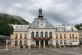 The town hall in Morez | |
Location of Hauts de Bienne | |
 Hauts de Bienne 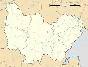 Hauts de Bienne | |
| Coordinates: 46°31′16″N 6°01′23″E / 46.521°N 6.023°E | |
| Country | France |
| Region | Bourgogne-Franche-Comté |
| Department | Jura |
| Arrondissement | Saint-Claude |
| Canton | Hauts de Bienne |
| Area 1 | 23.48 km2 (9.07 sq mi) |
| Population | 5,226 |
| • Density | 220/km2 (580/sq mi) |
| Time zone | UTC+01:00 (CET) |
| • Summer (DST) | UTC+02:00 (CEST) |
| INSEE/Postal code | 39368 /39400 |
| 1 French Land Register data, which excludes lakes, ponds, glaciers > 1 km2 (0.386 sq mi or 247 acres) and river estuaries. | |
Hauts de Bienne (French pronunciation: [o də bjɛn]) is a commune in the Jura department of eastern France. The municipality was established on 1 January 2016 by merger of the former communes of Morez, Lézat and La Mouille.[2] The commune was named after the river Bienne, that passes through it.
Population
| Year | Pop. | ±% p.a. |
|---|---|---|
| 1968 | 6,669 | — |
| 1975 | 7,072 | +0.84% |
| 1982 | 7,068 | −0.01% |
| 1990 | 7,354 | +0.50% |
| 1999 | 6,627 | −1.15% |
| 2007 | 5,833 | −1.58% |
| 2012 | 5,497 | −1.18% |
| 2017 | 5,350 | −0.54% |
| Source: INSEE[3] | ||
See also
References
Wikimedia Commons has media related to Hauts de Bienne.
- ↑ "Populations légales 2020". The National Institute of Statistics and Economic Studies. 29 December 2022.
- ↑ Arrêté préfectoral 29 December 2015 (in French)
- ↑ Population en historique depuis 1968, INSEE
This article is issued from Wikipedia. The text is licensed under Creative Commons - Attribution - Sharealike. Additional terms may apply for the media files.