Léaz | |
|---|---|
Commune | |
 | |
 Coat of arms | |
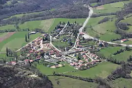
Location of Léaz | |
 Léaz  Léaz | |
| Coordinates: 46°05′53″N 5°53′12″E / 46.0981°N 5.8867°E | |
| Country | France |
| Region | Auvergne-Rhône-Alpes |
| Department | Ain |
| Arrondissement | Gex |
| Canton | Thoiry |
| Intercommunality | CA Pays de Gex |
| Government | |
| • Mayor (2020–2026) | Christine Blanc[1] |
| Area 1 | 11.4 km2 (4.4 sq mi) |
| Population | 796 |
| • Density | 70/km2 (180/sq mi) |
| Time zone | UTC+01:00 (CET) |
| • Summer (DST) | UTC+02:00 (CEST) |
| INSEE/Postal code | 01209 /01200 |
| Elevation | 330–1,507 m (1,083–4,944 ft) (avg. 446 m or 1,463 ft) |
| 1 French Land Register data, which excludes lakes, ponds, glaciers > 1 km2 (0.386 sq mi or 247 acres) and river estuaries. | |
Léaz (French pronunciation: [le.a]; Arpitan: Lèya) is a commune in the Ain department in eastern France.
In addition to the main village, the commune has three hamlets: Grésin, Lavoux and Longeray.
Population
| Year | Pop. | ±% |
|---|---|---|
| 1962 | 433 | — |
| 1968 | 405 | −6.5% |
| 1975 | 480 | +18.5% |
| 1982 | 482 | +0.4% |
| 1990 | 461 | −4.4% |
| 1999 | 481 | +4.3% |
| 2008 | 520 | +8.1% |
| 2014 | 687 | +32.1% |
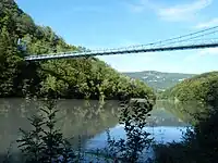
Grésin Bridge
See also
References
- ↑ "Répertoire national des élus: les maires" (in French). data.gouv.fr, Plateforme ouverte des données publiques françaises. 13 September 2022.
- ↑ "Populations légales 2020". The National Institute of Statistics and Economic Studies. 29 December 2022.
External links
Wikimedia Commons has media related to Léaz.
This article is issued from Wikipedia. The text is licensed under Creative Commons - Attribution - Sharealike. Additional terms may apply for the media files.