Boutteville | |
|---|---|
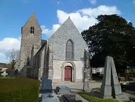 The church of Saint-Hermeland | |
Location of Boutteville | |
 Boutteville  Boutteville | |
| Coordinates: 49°23′24″N 1°15′28″W / 49.39°N 1.2578°W | |
| Country | France |
| Region | Normandy |
| Department | Manche |
| Arrondissement | Cherbourg |
| Canton | Carentan-les-Marais |
| Government | |
| • Mayor (2020–2026) | Michel Jourdan[1] |
| Area 1 | 1.82 km2 (0.70 sq mi) |
| Population | 69 |
| • Density | 38/km2 (98/sq mi) |
| Time zone | UTC+01:00 (CET) |
| • Summer (DST) | UTC+02:00 (CEST) |
| INSEE/Postal code | 50070 /50480 |
| Elevation | 3–38 m (9.8–124.7 ft) (avg. 20 m or 66 ft) |
| 1 French Land Register data, which excludes lakes, ponds, glaciers > 1 km2 (0.386 sq mi or 247 acres) and river estuaries. | |
Boutteville (French pronunciation: [butvil]) is a commune in the Manche department in Normandy in northwestern France.
Population
| Year | Pop. | ±% p.a. |
|---|---|---|
| 1968 | 72 | — |
| 1975 | 56 | −3.53% |
| 1982 | 64 | +1.93% |
| 1990 | 51 | −2.80% |
| 1999 | 62 | +2.19% |
| 2009 | 55 | −1.19% |
| 2014 | 62 | +2.42% |
| 2020 | 69 | +1.80% |
| Source: INSEE[3] | ||
See also
References
- ↑ "Répertoire national des élus: les maires". data.gouv.fr, Plateforme ouverte des données publiques françaises (in French). 2 December 2020.
- ↑ "Populations légales 2020". The National Institute of Statistics and Economic Studies. 29 December 2022.
- ↑ Population en historique depuis 1968, INSEE
Wikimedia Commons has media related to Boutteville.
This article is issued from Wikipedia. The text is licensed under Creative Commons - Attribution - Sharealike. Additional terms may apply for the media files.