Bettancourt-la-Longue | |
|---|---|
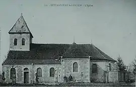 The church in 1912 | |
Location of Bettancourt-la-Longue | |
 Bettancourt-la-Longue 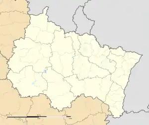 Bettancourt-la-Longue | |
| Coordinates: 48°49′46″N 4°53′21″E / 48.8294°N 4.8892°E | |
| Country | France |
| Region | Grand Est |
| Department | Marne |
| Arrondissement | Vitry-le-François |
| Canton | Sermaize-les-Bains |
| Government | |
| • Mayor (2020–2026) | Jean-Marie Tassinari[1] |
| Area 1 | 6.09 km2 (2.35 sq mi) |
| Population | 76 |
| • Density | 12/km2 (32/sq mi) |
| Time zone | UTC+01:00 (CET) |
| • Summer (DST) | UTC+02:00 (CEST) |
| INSEE/Postal code | 51057 /51330 |
| 1 French Land Register data, which excludes lakes, ponds, glaciers > 1 km2 (0.386 sq mi or 247 acres) and river estuaries. | |
Bettancourt-la-Longue (French pronunciation: [bɛtɑ̃kuʁ la lɔ̃ɡ]) is a commune in the Marne department in northeastern France.
Geography
The village lies on the right bank of the Chée, which flows southwest through the southeastern part of the commune.
Population
| Year | Pop. | ±% |
|---|---|---|
| 1962 | 86 | — |
| 1968 | 94 | +9.3% |
| 1975 | 79 | −16.0% |
| 1982 | 81 | +2.5% |
| 1990 | 78 | −3.7% |
| 1999 | 72 | −7.7% |
| 2006 | 85 | +18.1% |
| 2009 | 88 | +3.5% |
See also
References
- ↑ "Répertoire national des élus: les maires". data.gouv.fr, Plateforme ouverte des données publiques françaises (in French). 2 December 2020.
- ↑ "Populations légales 2020". The National Institute of Statistics and Economic Studies. 29 December 2022.
Wikimedia Commons has media related to Bettancourt-la-Longue.
This article is issued from Wikipedia. The text is licensed under Creative Commons - Attribution - Sharealike. Additional terms may apply for the media files.