Yuping County
玉屏县 Yü-p'ing | |
|---|---|
| 玉屏侗族自治县 Yuping Dong Autonomous County | |
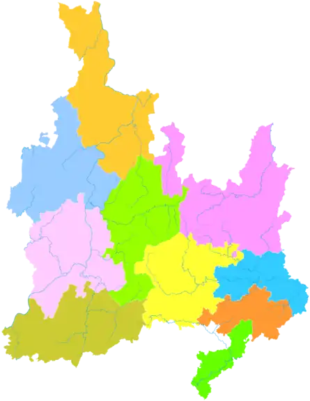 Yuping is the southernmost division in this map of Tongren | |
.png.webp) Tongren in Guizhou | |
 Yuping County  Yuping County | |
| Coordinates: 27°14′09″N 108°54′23″E / 27.2358°N 108.9064°E | |
| Country | China |
| Province | Guizhou |
| Prefecture-level city | Tongren |
| County seat | Zaojiaoping Subdistrict |
| Area | |
| • Total | 516 km2 (199 sq mi) |
| Population (2020 census)[1] | |
| • Total | 150,457 |
| • Density | 290/km2 (760/sq mi) |
| Time zone | UTC+8 (China Standard) |
| Website | www |
Yuping Dong Autonomous County (Chinese: 玉屏侗族自治县; pinyin: Yùpíng dòngzú Zìzhìxiàn) is an autonomous county under the administration of the prefecture-level city of Tongren, in the east of Guizhou Province, China, bordering Hunan Province to the southeast.
The county produces a special instrument "Yuping Flute" (玉屏箫笛).
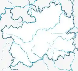
Administrative divisions

Map including Yuping (labeled as YÜ-P'ING (Walled) 玉屏) (AMS, 1954)
Yuping is divided into 4 subdistricts, 3 towns and 1 townships:
- Pingxi Subdistrict (平溪街道)
- Zaojiaoping Subdistrict (皂角坪街道)
- Mayintang Subdistrict (麻音塘街道)
- Dalong Subdistrict (大龙街道)
- Zhujiachang Town (朱家场镇)
- Tianping Town (田坪镇)
- Xindian Town (新店镇)
- Yayu Township (亚鱼乡)
Climate
| Climate data for Yuping (1991–2020 normals, extremes 1981–2010) | |||||||||||||
|---|---|---|---|---|---|---|---|---|---|---|---|---|---|
| Month | Jan | Feb | Mar | Apr | May | Jun | Jul | Aug | Sep | Oct | Nov | Dec | Year |
| Record high °C (°F) | 26.7 (80.1) |
32.2 (90.0) |
36.5 (97.7) |
36.7 (98.1) |
37.5 (99.5) |
37.8 (100.0) |
38.9 (102.0) |
39.7 (103.5) |
38.8 (101.8) |
35.2 (95.4) |
32.4 (90.3) |
24.0 (75.2) |
39.7 (103.5) |
| Average high °C (°F) | 8.7 (47.7) |
11.8 (53.2) |
16.3 (61.3) |
22.7 (72.9) |
26.6 (79.9) |
29.5 (85.1) |
32.5 (90.5) |
32.4 (90.3) |
28.5 (83.3) |
22.4 (72.3) |
17.2 (63.0) |
11.3 (52.3) |
21.7 (71.0) |
| Daily mean °C (°F) | 5.4 (41.7) |
7.7 (45.9) |
11.7 (53.1) |
17.3 (63.1) |
21.4 (70.5) |
24.7 (76.5) |
27.2 (81.0) |
26.7 (80.1) |
23.0 (73.4) |
17.7 (63.9) |
12.6 (54.7) |
7.4 (45.3) |
16.9 (62.4) |
| Average low °C (°F) | 3.2 (37.8) |
5.2 (41.4) |
8.7 (47.7) |
13.7 (56.7) |
17.8 (64.0) |
21.5 (70.7) |
23.4 (74.1) |
22.9 (73.2) |
19.5 (67.1) |
14.7 (58.5) |
9.7 (49.5) |
4.9 (40.8) |
13.8 (56.8) |
| Record low °C (°F) | −4.4 (24.1) |
−4.1 (24.6) |
−1.0 (30.2) |
3.5 (38.3) |
7.8 (46.0) |
13.1 (55.6) |
15.8 (60.4) |
16.0 (60.8) |
12.3 (54.1) |
2.3 (36.1) |
−1.0 (30.2) |
−3.5 (25.7) |
−4.4 (24.1) |
| Average precipitation mm (inches) | 45.1 (1.78) |
45.7 (1.80) |
84.5 (3.33) |
123.3 (4.85) |
176.4 (6.94) |
189.7 (7.47) |
166.8 (6.57) |
115.5 (4.55) |
85.6 (3.37) |
90.8 (3.57) |
59.9 (2.36) |
38.1 (1.50) |
1,221.4 (48.09) |
| Average precipitation days (≥ 0.1 mm) | 13.7 | 13.4 | 17.5 | 16.7 | 17.4 | 16.2 | 13.4 | 12.1 | 10.0 | 13.5 | 11.1 | 11.1 | 166.1 |
| Average snowy days | 4.6 | 2.5 | 0.5 | 0 | 0 | 0 | 0 | 0 | 0 | 0 | 0 | 1.7 | 9.3 |
| Average relative humidity (%) | 80 | 79 | 80 | 79 | 80 | 82 | 78 | 78 | 78 | 81 | 80 | 78 | 79 |
| Mean monthly sunshine hours | 36.4 | 45.1 | 62.6 | 88.4 | 105.1 | 102.2 | 171.5 | 174.4 | 125.2 | 84.4 | 73.7 | 57.4 | 1,126.4 |
| Percent possible sunshine | 11 | 14 | 17 | 23 | 25 | 25 | 41 | 43 | 34 | 24 | 23 | 18 | 25 |
| Source: China Meteorological Administration[2][3] | |||||||||||||
References
- ↑ "重磅!铜仁市第七次全国人口普查公报发布" (in Chinese). Government of Tongren. 2021-06-02.
- ↑ 中国气象数据网 – WeatherBk Data (in Simplified Chinese). China Meteorological Administration. Retrieved 28 April 2023.
- ↑ 中国气象数据网 (in Simplified Chinese). China Meteorological Administration. Retrieved 28 April 2023.
External links
This article is issued from Wikipedia. The text is licensed under Creative Commons - Attribution - Sharealike. Additional terms may apply for the media files.