Xuecheng District
薛城区 | |
|---|---|
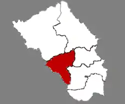 Location in Zaozhuang | |
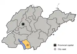 Zaozhuang in Shandong | |
| Coordinates: 34°46′28″N 117°15′05″E / 34.77444°N 117.25139°E | |
| Country | People's Republic of China |
| Province | Shandong |
| Prefecture-level city | Zaozhuang |
| Area | |
| • Total | 423.02 km2 (163.33 sq mi) |
| Population (2016) | |
| • Total | 462,500 |
| • Density | 1,100/km2 (2,800/sq mi) |
| Time zone | UTC+8 (China Standard) |
| Postal code | 277000 |
Xuecheng (Chinese: 薛城区; pinyin: Xuēchéng Qū) is a district and the seat of Zaozhuang, Shandong province, China, ever named by "lin cheng ". It has an area of 506.72 km2 and around 405,285 inhabitants (2003).
Administrative divisions
As 2012, this district is divided to 3 subdistricts and 6 towns.[1]
- Subdistricts
- Lincheng Subdistrict (临城街道)
- Xingren Subdistrict (兴仁街道)
- Xingcheng Subdistrict (兴城街道)
- Towns
|
|
Climate
| Climate data for Xuecheng (1999–2020 normals, extremes 1981–2010) | |||||||||||||
|---|---|---|---|---|---|---|---|---|---|---|---|---|---|
| Month | Jan | Feb | Mar | Apr | May | Jun | Jul | Aug | Sep | Oct | Nov | Dec | Year |
| Record high °C (°F) | 16.7 (62.1) |
25.0 (77.0) |
28.2 (82.8) |
33.2 (91.8) |
37.9 (100.2) |
38.0 (100.4) |
39.9 (103.8) |
37.0 (98.6) |
35.5 (95.9) |
32.0 (89.6) |
25.9 (78.6) |
21.1 (70.0) |
39.9 (103.8) |
| Average high °C (°F) | 5.5 (41.9) |
8.8 (47.8) |
15.1 (59.2) |
21.4 (70.5) |
26.9 (80.4) |
30.9 (87.6) |
31.7 (89.1) |
30.8 (87.4) |
27.3 (81.1) |
21.7 (71.1) |
14.1 (57.4) |
7.1 (44.8) |
20.1 (68.2) |
| Daily mean °C (°F) | 1.2 (34.2) |
4.1 (39.4) |
9.9 (49.8) |
16.0 (60.8) |
21.6 (70.9) |
25.8 (78.4) |
27.4 (81.3) |
26.7 (80.1) |
22.7 (72.9) |
16.9 (62.4) |
9.6 (49.3) |
3.0 (37.4) |
15.4 (59.7) |
| Average low °C (°F) | −2.1 (28.2) |
0.5 (32.9) |
5.5 (41.9) |
11.3 (52.3) |
16.9 (62.4) |
21.4 (70.5) |
24.0 (75.2) |
23.4 (74.1) |
18.9 (66.0) |
12.9 (55.2) |
6.0 (42.8) |
−0.3 (31.5) |
11.5 (52.8) |
| Record low °C (°F) | −12.6 (9.3) |
−12.2 (10.0) |
−9.3 (15.3) |
−0.5 (31.1) |
4.7 (40.5) |
12.4 (54.3) |
16.5 (61.7) |
12.9 (55.2) |
6.8 (44.2) |
−1.0 (30.2) |
−8.5 (16.7) |
−12.4 (9.7) |
−12.6 (9.3) |
| Average precipitation mm (inches) | 13.2 (0.52) |
16.8 (0.66) |
18.1 (0.71) |
38.4 (1.51) |
66.4 (2.61) |
85.0 (3.35) |
239.5 (9.43) |
185.5 (7.30) |
72.7 (2.86) |
33.2 (1.31) |
32.7 (1.29) |
16.2 (0.64) |
817.7 (32.19) |
| Average precipitation days (≥ 0.1 mm) | 3.6 | 4.4 | 4.3 | 6.2 | 6.3 | 7.4 | 12.8 | 12.0 | 7.3 | 6.0 | 5.5 | 4.0 | 79.8 |
| Average snowy days | 3.0 | 2.6 | 0.5 | 0 | 0 | 0 | 0 | 0 | 0 | 0 | 0.5 | 1.3 | 7.9 |
| Average relative humidity (%) | 60 | 59 | 55 | 58 | 62 | 65 | 79 | 79 | 72 | 65 | 65 | 62 | 65 |
| Mean monthly sunshine hours | 133.6 | 137.0 | 193.2 | 212.6 | 226.1 | 197.3 | 176.7 | 171.8 | 162.1 | 161.1 | 146.3 | 145.7 | 2,063.5 |
| Percent possible sunshine | 43 | 44 | 52 | 54 | 52 | 46 | 40 | 42 | 44 | 46 | 48 | 48 | 47 |
| Source: China Meteorological Administration[2][3] | |||||||||||||
References
- ↑ 东营市-行政区划网 www.xzqh.org (in Chinese). XZQH. Retrieved 2012-05-24.
- ↑ 中国气象数据网 – WeatherBk Data (in Simplified Chinese). China Meteorological Administration. Retrieved 12 August 2023.
- ↑ 中国气象数据网 (in Simplified Chinese). China Meteorological Administration. Retrieved 12 August 2023.
External links
This article is issued from Wikipedia. The text is licensed under Creative Commons - Attribution - Sharealike. Additional terms may apply for the media files.