| Willow Brook | |
|---|---|
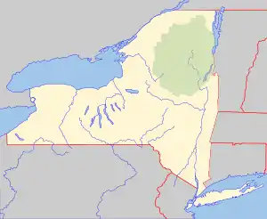 Location of the mouth of Willow Brook  Willow Brook (Otsego Lake tributary) (the United States) | |
| Location | |
| Country | United States |
| State | New York |
| Region | Central New York Region |
| County | Otsego |
| Town | Otsego |
| Physical characteristics | |
| Source | Moe Pond |
| • location | NW of Cooperstown |
| • coordinates | 42°42′51″N 74°56′42″W / 42.71417°N 74.94500°W |
| • elevation | 1,627 ft (496 m)[1] |
| Mouth | Otsego Lake |
• location | Cooperstown |
• coordinates | 42°42′12″N 74°55′23″W / 42.70333°N 74.92306°W[2] |
• elevation | 1,188 ft (362 m) |
| Basin features | |
| Progression | Willow Brook → Otsego Lake → Susquehanna River → Chesapeake Bay → Atlantic Ocean |
Willow Brook is a river in Otsego County, New York. It drains out of Moe Pond, flows through Cooperstown, and empties into Otsego Lake.[3]
References
- ↑ "Moe Pond". Geographic Names Information System. United States Geological Survey, United States Department of the Interior. Retrieved 2019-01-05.
- ↑ "Willow Brook". Geographic Names Information System. United States Geological Survey, United States Department of the Interior. Retrieved 2017-11-15.
- ↑ "28th Annual Report (1995)" (PDF). www.oneonta.edu. SUNY Oneonta Biological Field Station. 1996. Retrieved 17 April 2017.
This article is issued from Wikipedia. The text is licensed under Creative Commons - Attribution - Sharealike. Additional terms may apply for the media files.