| Walsingham | |
|---|---|
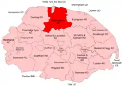 Boundaries from 1935 | |
| History | |
| • Created | 1894 |
| • Abolished | 1974 |
| • Succeeded by | North Norfolk |
| Status | Rural district |
| • HQ | Fakenham |
 Coat of arms of the rural district council[1] | |
Walsingham Rural District was a rural district in the county of Norfolk, England. It was created in 1894. On 1 April 1935 it was enlarged by the addition of the parishes of Hindolveston, Thurning, Wood Norton (from the disbanded Aylsham Rural District) and Briston (from the Erpingham Rural District).[2] On 1 April 1974 it was abolished under the Local Government Act 1972, and has since formed part of the District of North Norfolk.
Statistics
| Year | Area (ha) [3] |
Population [4] |
Density (pop/ha) |
|---|---|---|---|
| 1911 | 32,374 | 17,250 | 0.53 |
| 1921 | 16,214 | 0.50 | |
| 1931 | 15,815 | 0.49 | |
| 1951 | 35,944 | 22,893 | 0.64 |
| 1961 | 20,890 | 0.58 |
Parishes
| Parish | From | To | Notes |
|---|---|---|---|
| Alethorpe | 1935 | Added to Little Snoring | |
| Bale | 1935 | Added to Gunthorpe | |
| Barney | 1935 | Component of Fulmodeston | |
| Barsham | 1935 | Merger of East, North & West Barsham and Houghton St Giles | |
| Binham | |||
| Blakeney | |||
| Briningham | |||
| Brinton | |||
| Briston | 1935 | Formerly Erpingham RD | |
| Cockthorpe | 1935 | Added to Binham | |
| Dunton | 1935 | Merger of Dunton cum Doughton, Shereford & Toftrees | |
| Dunton cum Doughton | 1935 | Component of Dunton | |
| East Barsham | 1935 | Component of Barsham | |
| East Raynham | 1935 | Component of Raynham | |
| Egmere | 1935 | Added to Great Walsingham | |
| Fakenham | |||
| Field Dalling | |||
| Fulmodeston | 1935 | Merger of Barney, Fulmodeston cum Croxton & Thursford | |
| Fulmodeston cum Croxton | 1935 | Component of Fulmodeston | |
| Great Ryburgh | |||
| Great Snoring | |||
| Great Walsingham | |||
| Gunthorpe | |||
| Helhoughton | |||
| Hempton | |||
| Hindolveston | 1935 | Formerly Aylsham RD | |
| Hindringham | |||
| Holkham | |||
| Houghton St Giles | 1935 | Component of Barsham | |
| Kettlestone | |||
| Langham | |||
| Little Ryburgh | |||
| Little Snoring | |||
| Little Walsingham | |||
| Melton Constable | |||
| Morston | |||
| North Barsham | 1935 | Component of Barsham | |
| Pensthorpe | 1935 | Added to Kettlestone | |
| Pudding Norton | |||
| Quarles | 1935 | Added to Great Walsingham | |
| Raynham | 1935 | Merger of East, South & West Raynham | |
| Saxlingham | 1935 | Added to Field Dalling | |
| Sculthorpe | |||
| Sharrington | 1935 | Added to Brinton | |
| Shereford | 1935 | Component of Dunton | |
| South Raynham | 1935 | Component of Raynham | |
| Stibbard | |||
| Stiffkey | |||
| Swanton Novers | |||
| Tatterford | 1935 | Added to Tattersett | |
| Tattersett | |||
| Testerton | 1935 | Added to Pudding Norton | |
| Thurning | 1935 | Formerly Aylsham RD | |
| Thursford | From 1935 to 1950 part of Fulmodeston | ||
| Toftrees | 1935 | Component of Dunton | |
| Warham | |||
| West Barsham | 1935 | Component of Barsham | |
| West Raynham | 1935 | Component of Raynham | |
| Wighton | |||
| Wiveton | |||
| Wood Norton | 1935 | Formerly Aylsham RD |
References
- ↑ "Walsingham - Coat of arms (crest) of Walsingham". Heraldry of the World. Retrieved 25 August 2022.
- ↑ "Walsingham RD through time: Census tables with data for the Local Government District". A Vision of Britain through Time. GB Historical GIS / University of Portsmouth. Retrieved 30 June 2017.
- ↑ "Walsingham RD through time: Population Statistics: Area (acres)". A Vision of Britain through Time. GB Historical GIS / University of Portsmouth. Retrieved 30 June 2017.
- ↑ "Walsingham RD through time: Population Statistics: Total Population". A Vision of Britain through Time. GB Historical GIS / University of Portsmouth. Retrieved 30 June 2017.
This article is issued from Wikipedia. The text is licensed under Creative Commons - Attribution - Sharealike. Additional terms may apply for the media files.