Walker Township | |
|---|---|
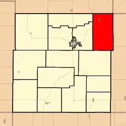 Location in Anderson County | |
| Coordinates: 38°22′10″N 095°06′41″W / 38.36944°N 95.11139°W | |
| Country | United States |
| State | Kansas |
| County | Anderson |
| Area | |
| • Total | 45.3 sq mi (117.3 km2) |
| • Land | 44.9 sq mi (116.4 km2) |
| • Water | 0.3 sq mi (0.9 km2) 0.79% |
| Elevation | 909 ft (277 m) |
| Population (2010) | |
| • Total | 668 |
| • Density | 15/sq mi (5.7/km2) |
| GNIS feature ID | 0477612 |
Walker Township is a township in Anderson County, Kansas, United States. As of the 2010 census, its population was 668.[1]
History
Walker Township was established in 1857. It was named for Robert J. Walker, fourth Territorial Governor of Kansas.[2]
Geography
Walker Township covers an area of 45.3 square miles (117.3 km2) and contains one incorporated settlement, Greeley. According to the USGS, it contains two cemeteries: Saint John and Sutton Valley.
The stream of South Fork Pottawatomie Creek runs through this township.
References
- ↑ "Geographic Identifiers: 2010 Demographic Profile Data (G001): Walker township, Anderson County, Kansas". U.S. Census Bureau, American Factfinder. Archived from the original on February 12, 2020. Retrieved May 13, 2013.
- ↑ Johnson, William A. (1877). The History of Anderson County, Kansas, from Its First Settlement to the Fourth of July, 1876. Kauffman & Iler. pp. 245–246.
External links
Municipalities and communities of Anderson County, Kansas, United States | ||
|---|---|---|
| Cities | 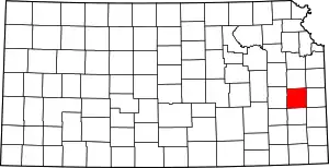 Map of Kansas highlighting Anderson County | |
| Unincorporated communities | ||
| Ghost town | ||
| Townships | ||
| Footnotes | †This community is designated a Census-Designated Place (CDP) by the United States Census Bureau. | |
This article is issued from Wikipedia. The text is licensed under Creative Commons - Attribution - Sharealike. Additional terms may apply for the media files.