Vazineh District
Persian: بخش وزینه | |
|---|---|
 Vazineh District | |
| Coordinates: 36°19′13″N 45°24′33″E / 36.32028°N 45.40917°E[1] | |
| Country | |
| Province | West Azerbaijan |
| County | Sardasht |
| Capital | Mirabad |
| Population (2016)[2] | |
| • Total | 32,259 |
| Time zone | UTC+3:30 (IRST) |
Vazineh District (Persian: بخش وزینه) is in Sardasht County, West Azerbaijan province, Iran.
At the 2006 National Census, its population was 31,369 in 5,343 households.[3] The following census in 2011 counted 31,040 people in 6,825 households.[4] At the latest census in 2016, the district had 32,259 inhabitants in 8,085 households.[2]
| Administrative Divisions | 2006[3] | 2011[4] | 2016[2] |
|---|---|---|---|
| Gavork-e Nalin RD | 10,682 | 10,065 | 9,958 |
| Melkari RD | 16,185 | 15,545 | 16,301 |
| Mirabad (city) | 4,502 | 5,430 | 6,000 |
| Total | 31,369 | 31,040 | 32,259 |
| RD: Rural District | |||
References
- ↑ OpenStreetMap contributors (8 March 2023). "Vazineh District (Sardasht County)" (Map). OpenStreetMap. Retrieved 8 March 2023.
- 1 2 3 "Census of the Islamic Republic of Iran, 1395 (2016)". AMAR (in Persian). The Statistical Center of Iran. p. 04. Archived from the original (Excel) on 30 August 2022. Retrieved 19 December 2022.
- 1 2 "Census of the Islamic Republic of Iran, 1385 (2006)". AMAR (in Persian). The Statistical Center of Iran. p. 04. Archived from the original (Excel) on 20 September 2011. Retrieved 25 September 2022.
- 1 2 "Census of the Islamic Republic of Iran, 1390 (2011)" (Excel). Iran Data Portal (in Persian). The Statistical Center of Iran. p. 04. Retrieved 19 December 2022.
West Azerbaijan province, Iran | ||
|---|---|---|
| Capital | 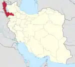 | |
| Counties and cities | ||
| Tourism | ||
| Places | ||
This article is issued from Wikipedia. The text is licensed under Creative Commons - Attribution - Sharealike. Additional terms may apply for the media files.