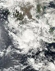
 Tropical Storm Max making landfall on Guerrero at peak intensity on October 9, 2023. | |
| Meteorological history | |
|---|---|
| Formed | October 8, 2023 |
| Dissipated | October 10, 2023 |
| Tropical storm | |
| 1-minute sustained (SSHWS/NWS) | |
| Highest winds | 65 mph (100 km/h) |
| Lowest pressure | 991 mbar (hPa); 29.26 inHg |
| Overall effects | |
| Fatalities | 2 total |
| Damage | Unknown |
| Areas affected | Southwestern Mexico, Gulf Coast of the United States |
Part of the 2023 Pacific hurricane season | |
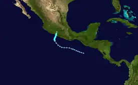
Tropical Storm Max was the first of four tropical cyclones to make landfall along the Pacific Coast of Mexico in October 2023. The sixteenth tropical depression and thirteenth named storm of the 2023 Pacific hurricane season, Max originated from a trough of low pressure that developed to the southwest of Central America on October 3, 2023. Showers and thunderstorms associated with the disturbance gradually became better organized over the following days as it moved west-northwestwards to the south of Mexico. The disturbance was designated Potential Tropical Cyclone Sixteen-E on October 7 by the United States National Hurricane Center (NHC), as it had not yet become a tropical cyclone but was threatening the southwestern coast of Mexico. The disturbance developed a more well-defined circulation the following day and developed into a tropical depression; the depression strengthened into a tropical storm late on October 8 and was assigned the name Max. Max progressed northward toward the coast of Mexico and quickly strengthened; the storm made landfall near Puerto Vicente Guerrero, Guerrero at 18:00 UTC on October 9. Max rapidly weakened as it moved inland over Mexico and dissipated the following morning over the Sierra Nevada mountains.
Max resulted in significant flooding and strong winds across much of the coast of southwestern Mexico. Two deaths were reported in the Mexican state of Guerrero due to the storm, while an additional two people were seriously injured. Areas of southern Mexico affected by Max, particularly Guerrero, were severely affected by the much more powerful Hurricane Otis just two weeks after Max's landfall.
Meteorological history
Tropical storm (39–73 mph, 63–118 km/h)
Category 1 (74–95 mph, 119–153 km/h)
Category 2 (96–110 mph, 154–177 km/h)
Category 3 (111–129 mph, 178–208 km/h)
Category 4 (130–156 mph, 209–251 km/h)
Category 5 (≥157 mph, ≥252 km/h)
Unknown
A large area of shower and thunderstorm activity developed to the south of Central America around 6:00 UTC on October 4, in association with a trough of low pressure.[1] The disturbance progressed slowly northwestward within an environment conducive to tropical cyclogenesis.[2] The convective (shower and thunderstorm) activity associated with the disturbance initially remained limited and disorganized;[3] however, the system began to become more organized on October 6 amid favorable environmental conditions while located just southwest of the Gulf of Tehuantepec.[4] The disturbance continued to become better organized and develop more convective activity over the following day, although it still lacked curvature in its rainbands and a well-defined center;[5][6] despite this, due to the impending threat it posed to the Mexican coastline, it was designated a potential tropical cyclone at 3:00 UTC on October 8 and given the designation Sixteen-E.[7]
.jpg.webp)
Sixteen-E continued to develop a more organized, cyclonic structure throughout the day on October 8 as it moved slowly northwest, between a ridge to its east and Tropical Storm Lidia to its west.[6] The development of a more well-defined center and tight, spiral rainbands allowed the system to finally develop into a tropical depression at 21:00 UTC that day, just south of Zihuatanejo. An increase in convective intensity and the development of gale-force winds allowed Sixteen-E to strengthen to a tropical storm six hours later, and it was assigned the name Max.[8] Max continued to move northward and strengthen as it neared the Mexican coastline.[9] Max achieved peak intensity as a strong tropical storm at 18:00 UTC on October 9, with maximum sustained winds of 65 mph (105 km/h) and a minimum barometric pressure of 991 mbar (29.3 inHg). The storm made landfall at peak intensity near the town of Puerto Vicente Guerrero shortly thereafter.[10] Max rapidly weakened as it moved inland over southern Mexico's mountainous terrain. By 9:00 UTC on October 10, the cyclone's winds had dropped below gale-force, and its center dissipated over the high terrain of the Sierra Nevada mountains in south-central Mexico.[11]
Preparations and impact
Tropical storm watches and warnings were issued for a broad swath of the southwestern coast of Mexico as Max approached the area, in anticipation of severe flooding and mudslides from the storm,[12] as well as predicted rainfall of up to 12 in (300 mm).[13] Shelters were set up in advance of the storm in the municipalities of Tecpán de Galeana, Petatlán, Coyuca de Benítez, Acapulco and Zihuatanejo de Azueta.[14] In-person classes were cancelled across Guerrero ahead of the cyclone's landfall, as well as in the states of Nayarit and Jalisco due to the dual threat of Max and the more powerful and northerly-tracking Hurricane Lidia.[15]
Widespread flooding of homes and roadways occurred along Max's track throughout Guerrero.[16] Extensive flooding, damage to homes, road closures, landslides, fence collapses, fallen trees and poles, and overflowing rivers were all reported across several coastal municipalities of Guerrero following Max's landfall.[17] Torrential rainfall was recorded throughout Michoacán, Guerrero and Oaxaca, with several areas reporting accumulations of up to 9.8 in (250 mm) across the latter two states.[18] Winds of up to 60 mph (95 km/h) were recorded as well.[19] Flash flooding washed out streets and public areas in Acapulco.[20] Max caused numerous rivers and streams to overflow their banks, which in turn flooded over 90 homes, four of which collapsed completely,[21] and felled many trees. Two deaths occurred in relation to Max,[22] both in the municipality of Tecpán de Galeana in Guerrero: one when a van fell into a sinkhole, and the other due to drowning in a flooded river.[14] The storm caused an additional sinkhole to form on a highway connecting Acapulco and Zihuatanejo along the coast.[21] Max created dangerous swells and rip currents across the Mexican coast, affecting the tropical storm warning area from Acapulco to Lázaro Cárdenas.[13] Max continued to generate heavy rains into October 10 and 11 as its remnant moisture spread inland.[14]
Following the storm, the Mexican federal government signed an emergency declaration for the municipalities of Benito Juárez, Atoyac de Álvarez, Tecpan de Galeana and Coyuca de Benítez, to allow affected residents to receive shelter, food and aid.[17] The damage Max delivered to crops, livestock and infrastructure across Guerrero would later be compounded by Hurricane Otis.[23] The influx of moisture from Max and Lidia caused several days of unseasonably cooler and wetter weather across several states in southwestern and central Mexico.[24] The remnants of the storms also combined with a frontal boundary over the Gulf of Mexico and contributed to beneficial rainfall along the Gulf Coast of the United States, which was suffering from drought conditions.[25]
See also
- Weather of 2023
- Tropical cyclones in 2023
- Timeline of the 2023 Pacific hurricane season
- List of Eastern Pacific tropical storms
- Other tropical cyclones named Max
- Tropical Storm Odile (2008) – Peaked at a comparable intensity and affected similar areas
- Tropical Storm Trudy (2014) – Another strong tropical storm that struck southern Mexico in October
- Tropical Storm Ileana (2018) – Had a similar intensity and effects
References
- ↑ Brown, Daniel (October 3, 2023). Seven-Day Graphical Tropical Weather Outlook (Report). Miami, Florida, United States: National Hurricane Center. Archived from the original on October 20, 2023. Retrieved October 24, 2023.
- ↑ Roberts, Dave (October 4, 2023). Seven-Day Graphical Tropical Weather Outlook (Report). Miami, Florida, United States: National Hurricane Center. Archived from the original on October 25, 2023. Retrieved October 24, 2023.
- ↑ Zelinsky, D. (October 6, 2023). Seven-Day Graphical Tropical Weather Outlook (Report). Miami, Florida, United States: National Hurricane Center. Archived from the original on October 25, 2023. Retrieved October 24, 2023.
- ↑ Reinhart, Amanda (October 6, 2023). Seven-Day Graphical Tropical Weather Outlook (Report). Miami, Florida, United States: National Hurricane Center. Archived from the original on October 25, 2023. Retrieved October 24, 2023.
- ↑ Blake, Eric (October 8, 2023). Potential Tropical Cyclone Sixteen-E Discussion Number 2 (Report). Miami, Florida, United States: National Hurricane Center. Archived from the original on October 29, 2023. Retrieved October 24, 2023.
- 1 2 Papin, Philippe (October 8, 2023). Potential Tropical Cyclone Sixteen-E Discussion Number 3 (Report). Miami, Florida, United States: National Hurricane Center. Archived from the original on October 25, 2023. Retrieved October 24, 2023.
- ↑ Brown, Daniel (October 7, 2023). Potential Tropical Cyclone Sixteen-E Discussion Number 1 (Report). Miami, Florida, United States: National Hurricane Center. Archived from the original on October 20, 2023. Retrieved October 24, 2023.
- ↑ Brown, Daniel; Hogsett, Wallace (October 8, 2023). Tropical Storm Max Discussion Number 5 (Report). Miami, Florida, United States: National Hurricane Center. Archived from the original on October 29, 2023. Retrieved October 24, 2023.
- ↑ Papin, Philippe (October 9, 2023). Tropical Storm Max Discussion Number 7 (Report). Miami, Florida, United States: National Hurricane Center. Archived from the original on October 29, 2023. Retrieved October 25, 2023.
- ↑ Papin, Philippe (October 9, 2023). Tropical Storm Max Discussion Number 8 (Report). Miami, Florida, United States: National Hurricane Center. Archived from the original on October 25, 2023. Retrieved October 25, 2023.
- ↑ Blake, Eric (October 10, 2023). Remnants of Max Discussion Number 10 (Report). Miami, Florida, United States: National Hurricane Center. Archived from the original on October 23, 2023. Retrieved October 25, 2023.
- ↑ "Tropical Storm MAX Advisory Archive". Miami, Florida, United States: National Hurricane Center. Archived from the original on October 21, 2023. Retrieved October 25, 2023.
- 1 2 "Tropical Storm "Max" hits Guerrero; Lidia to intensify into hurricane before Mexico landfall". The Watchers News. October 9, 2023. Archived from the original on October 15, 2023. Retrieved October 25, 2023.
- 1 2 3 "Tropical Storm Max leaves 2 dead, homes damaged in Guerrero". Mexico News Daily. October 10, 2023. Archived from the original on October 25, 2023. Retrieved October 25, 2023.
- ↑ "Tormenta tropical Max toca tierra en México y mantiene alerta a la población". Xinhua Español (in Mexican Spanish). October 10, 2023. Archived from the original on October 25, 2023. Retrieved October 25, 2023.
- ↑ "October 11, 2023 – Hurricane Lidia and Tropical Storm Max Swamp Western Mexico". National Aeronautics and Space Administration. October 11, 2023. Archived from the original on October 11, 2023. Retrieved October 25, 2023.
- 1 2 "Tormenta Tropical "Max": Emiten declaratoria de emergencia para 4 municipios de Guerrero". El Universal (in Mexican Spanish). October 12, 2023. Archived from the original on October 25, 2023. Retrieved October 25, 2023.
- ↑ "Trayectoria de la tormenta tropical Max, que toca tierra en Guerrero". Al Día Dallas (in Mexican Spanish). October 9, 2023. Archived from the original on October 25, 2023. Retrieved October 25, 2023.
- ↑ "Tropical Storm Max makes landfall in Mexico as country braces for Lidia". The Associated Press. October 9, 2023. Archived from the original on October 25, 2023. Retrieved October 25, 2023.
- ↑ "Mexico faces flooding after Hurricane Lidia, Tropical Storm Max batter coasts". NBC. October 10, 2023. Archived from the original on October 24, 2023. Retrieved October 25, 2023.
- 1 2 "Tormenta Tropical Max Deja Dos Muertos En Empobrecido Sur De México". Barron's (in Mexican Spanish). October 10, 2023. Archived from the original on October 25, 2023. Retrieved October 25, 2023.
- ↑ Ruano, Christian (October 11, 2023). "Hurricane Lidia barrels inland after slamming Mexico coast; one dead". Reuters. Archived from the original on October 10, 2023. Retrieved October 25, 2023.
- ↑ Jesus Dorantes (November 10, 2023). "Comunidades de Guerrero golpeadas primero por Max y luego por Otis piden apoyo". Uno TV (in Mexican Spanish). Retrieved November 22, 2023.
- ↑ Herrera, Olivia Vazquez (October 12, 2023). "Tras el paso de Lidia y Max, vuelven las altas temperaturas en 21 estados hoy 12 de octubre". Infobae (in Mexican Spanish). Archived from the original on October 25, 2023. Retrieved October 25, 2023.
- ↑ Speck, Emilee; Wulfeck, Andrew (October 10, 2023). "Moisture from Pacific tropical cyclones, frontal boundary to soak drought-stricken Gulf Coast". Fox Weather. Archived from the original on October 27, 2023. Retrieved October 27, 2023.
External links
- The National Hurricane Center's advisory archive on Tropical Storm Max
![]() This article incorporates public domain material from websites or documents of the National Weather Service.
This article incorporates public domain material from websites or documents of the National Weather Service.
Tropical cyclones of the 2023 Pacific hurricane season | ||
|---|---|---|
 | ||
| ||