Topsy, Kansas | |
|---|---|
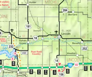 KDOT map of Lincoln County (legend) | |
 Topsy  Topsy | |
| Coordinates: 38°55′46″N 98°02′26″W / 38.92944°N 98.04056°W | |
| Country | United States |
| State | Kansas |
| County | Lincoln |
| Elevation | 1,453 ft (443 m) |
| Population | |
| • Total | 0 |
| Time zone | UTC-6 (CST) |
| • Summer (DST) | UTC-5 (CDT) |
| Area code | 785 |
| GNIS ID | 482329 [1] |
Topsy is a ghost town in Lincoln County, Kansas, United States.[1]
History
Topsy was issued a post office in 1879. The post office was discontinued in 1886.[2]
References
- 1 2 "Topsy, Kansas", Geographic Names Information System, United States Geological Survey, United States Department of the Interior
- ↑ "Kansas Post Offices, 1828-1961". Kansas Historical Society. Retrieved 2018-01-05.
Municipalities and communities of Lincoln County, Kansas, United States | ||
|---|---|---|
| Cities | 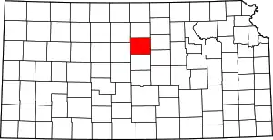 Map of Kansas highlighting Lincoln County | |
| Unincorporated communities | ||
| Ghost towns | ||
This article is issued from Wikipedia. The text is licensed under Creative Commons - Attribution - Sharealike. Additional terms may apply for the media files.