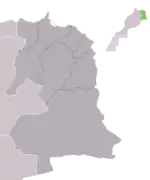
Taourirt Province
ⵜⴰⵏⴻⴱⴹⵉⵜ ⵏ ⵜⴰⵡⵔⵉⵔⵜ | |
|---|---|
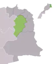 Taourirt Province, Oriental Region, Morocco | |
| Country | |
| Region | Oriental |
| Capital | Taourirt |
| Population (2004) | |
| • Total | 206,762 |
Taourirt is a province in the Oriental Region of Morocco. Its population in 2004 is 206,762 [1]
The major cities and towns are:[2]
Subdivisions
The province is divided administratively into the following:[3]
| Name | Geographic code | Type | Households | Population (2004) | Foreign population | Moroccan population | Notes |
|---|---|---|---|---|---|---|---|
| Debdou | 533.01.13. | Municipality | 908 | 4540 | 7 | 4533 | |
| El Aioun Sidi Mellouk | 533.01.15. | Municipality | 6379 | 34767 | 53 | 34714 | |
| Taourirt | 533.01.33. | Municipality | 14613 | 80024 | 104 | 79920 | |
| El Atef | 533.03.05. | Rural commune | 350 | 2471 | 0 | 2471 | |
| Oulad M'Hammed | 533.03.15. | Rural commune | 326 | 2174 | 0 | 2174 | |
| Sidi Ali Belkassem | 533.03.17. | Rural commune | 1865 | 13919 | 1 | 13918 | |
| Sidi Lahsen | 533.03.19. | Rural commune | 1302 | 9759 | 5 | 9754 | |
| Ain Lehjer | 533.07.03. | Rural commune | 1443 | 9210 | 4 | 9206 | |
| Mechraa Hammadi | 533.07.09. | Rural commune | 1150 | 7435 | 1 | 7434 | |
| Mestegmer | 533.07.13. | Rural commune | 1094 | 6378 | 1 | 6377 | |
| Tancherfi | 533.07.21. | Rural commune | 1088 | 7452 | 0 | 7452 | |
| Ahl Oued Za | 533.09.01. | Rural commune | 2161 | 14202 | 5 | 14197 | |
| Gteter | 533.09.07. | Rural commune | 946 | 6732 | 0 | 6732 | |
| Melg El Ouidane | 533.09.11. | Rural commune | 1251 | 7699 | 1 | 7698 | |
References
- ↑ "World Gazetteer: Taourirt - profile of geographical entity including name variants". www.world-gazetteer.com. Archived from the original on 9 February 2013. Retrieved 3 February 2022.
- ↑ "World Gazetteer: Taourirt - largest cities (Per geographical entity)". www.world-gazetteer.com. Archived from the original on 9 February 2013. Retrieved 3 February 2022.
- ↑ "Recensement général de la population et de l'habitat de 2004" (PDF). Haut-commissariat au Plan, Lavieeco.com. Retrieved 27 April 2012.
34°24′20″N 2°54′01″W / 34.40556°N 2.90028°W
Capital: Taourirt | ||
| Municipalities | | |
| Rural communes | ||
This article is issued from Wikipedia. The text is licensed under Creative Commons - Attribution - Sharealike. Additional terms may apply for the media files.