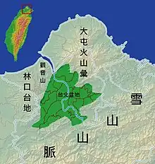
The Taipei Basin (traditional Chinese: 臺北盆地; simplified Chinese: 台北盆地; pinyin: Táiběi Péndì) is a geographic region in northern Taiwan. It is the largest basin in Taiwan. The basin is bounded by the Yangmingshan to the north, the Linkou Plateau to the west, and the Ridge of Xueshan Range to the southeast. The shape of the basin is close to a triangle. The three vertices are Nangang, Huilong of Xinzhuang, and Guandu of Beitou. Today, Taipei is the capital of Taiwan and the development center of the Taipei Basin, as well as one of the world's major cities.
Geology
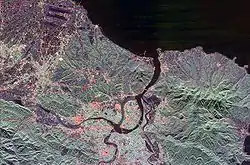
The Taipei Basin is a subsiding half-graben. The main rivers in the Taipei Basin include the Tamsui, Keelung, Dahan and Xindian..[1]
Pollution
The Taipei Basin rivers are heavily polluted by both raw sewage and industrial pollution from illegal industry. The natural river restoration is on the agenda of the Taipei City Government and several citizen organizations.[2]
See also
References
- ↑ Chen, Cheng-Hong (2013). "Volcanic activities in Taiwan: the past, present and future" (PDF). The 2013 International Training Workshop on Earth Sciences, Taipei. National Science and Technology Center for Disaster Reduction, Taiwan. Retrieved 29 November 2016.
- ↑ Taipei from the River - Marco Casagrande, E-Architect March, 2011
| Mountain ranges |
|  |
|---|---|---|
| Plateaus and hill lands | ||
| Plains | ||
| Basins | ||
| Volcano groups | ||
* The place names listed above are mainly romanized as Wade–Giles that used in most of academic articles. | ||