Tabas County
Persian: شهرستان طبس | |
|---|---|
County | |
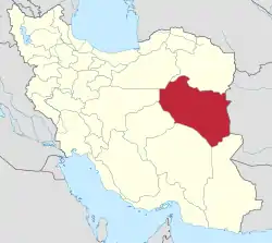
.svg.png.webp) Location of Tabas County in South Khorasan province | |
 Location of South Khorasan province in Iran | |
| Coordinates: 33°26′N 56°48′E / 33.433°N 56.800°E[1] | |
| Country | |
| Province | South Khorasan |
| Capital | Tabas |
| Districts | Central, Dastgerdan, Deyhuk |
| Population (2016)[2] | |
| • Total | 72,617 |
| Time zone | UTC+3:30 (IRST) |
| Tabas County can be found at GEOnet Names Server, at this link, by opening the Advanced Search box, entering "9207378" in the "Unique Feature Id" form, and clicking on "Search Database". | |
Tabas County (Persian: شهرستان طبس) is in South Khorasan province, Iran. Its capital is the city of Tabas.[3] It was a part of Ferdows County in Khorasan province until July 1960.[4] Tabas County became a part of Yazd province in 2001.[5]
At the 2006 census, the county's population was 63,047 in 16,845 households.[6] The following census in 2011 counted 69,658 people in 19,745 households.[7] Tabas County became a part of South Khorasan province in 2013.[8] At the 2016 census the county's population was 72,617, in 22,142 households.[2]
Administrative divisions
The population history of Tabas County's administrative divisions over three consecutive censuses is shown in the following table. The latest census shows three districts, eight rural districts, and three cities.[2]
| Administrative Divisions | 2006[6] | 2011[7] | 2016[2] |
|---|---|---|---|
| Central District | 43,188 | 48,569 | 52,528 |
| Golshan RD | 4,002 | 4,364 | 4,474 |
| Montazeriyeh RD | 4,350 | 4,816 | 4,489 |
| Nakhlestan RD | 3,122 | 3,446 | 3,081 |
| Pir Hajat RD | 1,033 | 793 | 808 |
| Tabas (city) | 30,681 | 35,150 | 39,676 |
| Dastgerdan District | 11,659 | 10,826 | 10,255 |
| Dastgerdan RD | 4,421 | 4,237 | 4,241 |
| Kuh Yakhab RD | 2,764 | 1,966 | 2,049 |
| Eshqabad (city) | 4,474 | 4,623 | 3,965 |
| Deyhuk District | 8,200 | 10,263 | 9,834 |
| Deyhuk RD | 1,926 | 2,502 | 2,793 |
| Kavir RD | 3,507 | 4,415 | 4,082 |
| Deyhuk (city) | 2,767 | 3,346 | 2,959 |
| Total | 63,047 | 69,658 | 72,617 |
| RD: Rural District 1As a county of Yazd province at the 2006 and 2011 censuses | |||
References
- ↑ OpenStreetMap contributors (23 March 2023). "Central District (Tabas County)" (Map). OpenStreetMap. Retrieved 23 March 2023.
- 1 2 3 4 "Census of the Islamic Republic of Iran, 1395 (2016)". AMAR (in Persian). The Statistical Center of Iran. p. 29. Archived from the original (Excel) on 17 October 2020. Retrieved 19 December 2022.
- ↑ طبس به خراسان جنوبی ملحق شد. (in Persian). ISNA. Retrieved 29 March 2013.
- ↑ تاریخچه فرمانداری در وبگاه فرمانداری شهرستان فردوس (in Persian).
- ↑ معرفی شهرستان طبس، پیشینه تاریخی (in Persian). Yazd Province Governorship. Archived from the original on 16 November 2012. Retrieved 29 March 2013.
- 1 2 "Census of the Islamic Republic of Iran, 1385 (2006)". AMAR (in Persian). The Statistical Center of Iran. p. 21. Archived from the original (Excel) on 20 September 2011. Retrieved 25 September 2022.
- 1 2 "Census of the Islamic Republic of Iran, 1390 (2011)" (Excel). Iran Data Portal (in Persian). The Statistical Center of Iran. p. 21. Retrieved 19 December 2022.
- ↑ Rahimi, Mohammad Reza (19 December 2013). "Approval letter regarding the abstraction of Tabas County from Yazd province and its annexation to South Khorasan province". Research Center of the System of Laws of the Islamic Council of the Farabi Library (in Persian). Ministry of Interior, Council of Ministers. Archived from the original on 29 May 2013. Retrieved 25 November 2023.
South Khorasan Province, Iran | |||||||||||||||||||||||
|---|---|---|---|---|---|---|---|---|---|---|---|---|---|---|---|---|---|---|---|---|---|---|---|
| Capital | 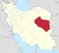   | ||||||||||||||||||||||
| Counties and cities |
| ||||||||||||||||||||||
| Sights |
| ||||||||||||||||||||||
| Populated places | |||||||||||||||||||||||