Summit Township | |
|---|---|
 Summit Township Location in Arkansas | |
| Coordinates: 36°10′12.45″N 93°15′2.84″W / 36.1701250°N 93.2507889°W | |
| Country | |
| State | |
| County | Boone |
| Area | |
| • Total | 32.277 sq mi (83.60 km2) |
| • Land | 32.201 sq mi (83.40 km2) |
| • Water | 0.076 sq mi (0.20 km2) |
| Population (2010) | |
| • Total | 556 |
| • Density | 17.27/sq mi (6.67/km2) |
| Time zone | UTC-6 (CST) |
| • Summer (DST) | UTC-5 (CDT) |
| Zip Code | 72601 (Harrison) |
| Area code | 870 |
Summit Township is one of twenty current townships in Boone County, Arkansas, USA].[1] At the 2010 census, its total population was 556.
Geography
According to the United States Census Bureau, Summit Township covers an area of 32.277 square miles (83.60 km2); 32.201 square miles (83.40 km2) of land and 0.076 square miles (0.20 km2) of water.
Population history
| Census | Pop. | Note | %± |
|---|---|---|---|
| 1880 | 341 | — | |
| 1890 | 425 | 24.6% | |
| 1900 | 399 | −6.1% | |
| 1910 | 343 | −14.0% | |
| 1920 | 352 | 2.6% | |
| 1930 | 236 | −33.0% | |
| 1940 | 264 | 11.9% | |
| 1950 | 262 | −0.8% | |
| 1960 | 183 | −30.2% | |
| 1970 | 257 | 40.4% | |
| 1980 | 288 | 12.1% | |
| 1990 | 387 | 34.4% | |
| 2000 | 491 | 26.9% | |
| 2010 | 556 | 13.2% |
References
- United States Census Bureau 2008 TIGER/Line Shapefiles
- United States Board on Geographic Names (GNIS)
- United States National Atlas
- ↑ "Summit Township, Boone County, Arkansas." U.S. Census Bureau. Breakdown. Retrieved June 2, 2012.
External links
Municipalities and communities of Boone County, Arkansas, United States | ||
|---|---|---|
| Cities | 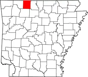 Map of Arkansas highlighting Boone County | |
| Towns | ||
| Townships | ||
| CDP | ||
| Other unincorporated communities | ||
| Ghost town | ||
| Footnotes | ‡This populated place also has portions in an adjacent county or counties | |
This article is issued from Wikipedia. The text is licensed under Creative Commons - Attribution - Sharealike. Additional terms may apply for the media files.