Steinerkirchen an der Traun | |
|---|---|
 | |
 Coat of arms | |
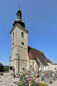
 Steinerkirchen an der Traun Location within Austria | |
| Coordinates: 48°04′43″N 13°57′30″E / 48.07861°N 13.95833°E | |
| Country | Austria |
| State | Upper Austria |
| District | Wels-Land |
| Government | |
| • Mayor | Thomas Steinerberger (ÖVP) |
| Area | |
| • Total | 32.55 km2 (12.57 sq mi) |
| Elevation | 381 m (1,250 ft) |
| Population (2018-01-01)[2] | |
| • Total | 2,371 |
| • Density | 73/km2 (190/sq mi) |
| Time zone | UTC+1 (CET) |
| • Summer (DST) | UTC+2 (CEST) |
| Postal code | 4652 |
| Area code | 07241 |
| Vehicle registration | WL |
| Website | www.steinerkirchen.at |
Steinerkirchen an der Traun is a municipality in the district of Wels-Land in the Austrian state of Upper Austria.
Population
| Year | Pop. | ±% |
|---|---|---|
| 1991 | 2,068 | — |
| 2001 | 2,149 | +3.9% |
| 2007 | 2,355 | +9.6% |
References
- ↑ "Dauersiedlungsraum der Gemeinden Politischen Bezirke und Bundesländer - Gebietsstand 1.1.2018". Statistics Austria. Retrieved 10 March 2019.
- ↑ "Einwohnerzahl 1.1.2018 nach Gemeinden mit Status, Gebietsstand 1.1.2018". Statistics Austria. Retrieved 9 March 2019.
Wikimedia Commons has media related to Steinerkirchen an der Traun.
This article is issued from Wikipedia. The text is licensed under Creative Commons - Attribution - Sharealike. Additional terms may apply for the media files.