Steele, Arkansas | |
|---|---|
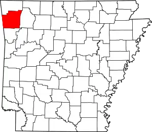
 Steele, Arkansas Steele's position in Arkansas | |
| Coordinates: 36°08′37″N 94°14′21″W / 36.14361°N 94.23917°W | |
| Country | |
| State | |
| County | Washington |
| Township | Tontitown |
| Elevation | 363 m (1,191 ft) |
| Time zone | UTC-6 (Central (CST)) |
| • Summer (DST) | UTC-5 (CDT) |
| ZIP code | 72762 |
| Area code | 479 |
| GNIS feature ID | 81632 |
| U.S. Geological Survey Geographic Names Information System: Steele, Arkansas | |
Steele is an unincorporated community in Tontitown Township, Washington County, Arkansas, United States.[1] It is located at the intersection of Barrington Road and Arbor Acres Road in Tontitown.[2]
References
- 1 2 "Steele, Arkansas". Geographic Names Information System. United States Geological Survey. Retrieved April 7, 2012.
- ↑ Arkansas Atlas and Gazetteer (Map) (Second ed.). DeLorme. § 22.
This article is issued from Wikipedia. The text is licensed under Creative Commons - Attribution - Sharealike. Additional terms may apply for the media files.