 | |
|---|---|
 | |
| Route information | |
| Length | 852 km (529 mi) |
| Major junctions | |
| North end | Ünye (Black Sea coast) |
| South end | Öncüpınar (Syrian border) |
| Location | |
| Country | Turkey |
| Highway system | |
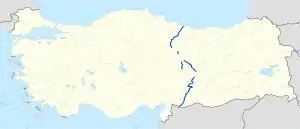
D.850 is a north to south state road in Turkey. It starts at Ünye at Black Sea coast and ends at Öncüpınar, the Syrian border check point.[1] Since it runs all the way from north to south it crosses the three main west to east highways namely D.100, D.300 and D.400.
Itinerary
| Province | Location | Distance from Ünye (km) |
Distance from Ünye (mile) |
Distance from Öncüpınar (km) |
Distance from Öncüpınar (mile) |
|---|---|---|---|---|---|
| Ordu | Ünye | 0 | 0 | 852 | 529 |
| Tokat | |||||
| Niksar | 107 | 66 | 745 | 463 | |
| Tokat | 161 | 100 | 691 | 429 | |
| Sivas | |||||
| Yıldızeli | 222 | 138 | 630 | 391 | |
| Sivas | 263 | 163 | 589 | 366 | |
| Gürün | 405 | 252 | 447 | 278 | |
| Malatya | |||||
| Darende | 441 | 271 | 411 | 255 | |
| Malatya[2] | 532 | 331 | 320 | 199 | |
| Kahramanmaraş | |||||
| Gölbaşı | 632 | 393 | 220 | 137 | |
| Besni | 675 | 419 | 177 | 110 | |
| Gaziantep | |||||
| Araban | 714 | 444 | 138 | 86 | |
| Gaziantep | 779 | 484 | 73 | 45 | |
| Kilis | |||||
| Kilis | 884 | 524 | 8 | 5 | |
| Öncüpınar | 852 | 529 | 0 | 0 |
References and notes
| East–west highways | ||
|---|---|---|
| North–south highways |
| |
Main highways highlighted | ||
This article is issued from Wikipedia. The text is licensed under Creative Commons - Attribution - Sharealike. Additional terms may apply for the media files.