South Athens
Περιφερειακή ενότητα Νοτίου Τομέα Αθηνών | |
|---|---|
 Municipalities of the former Athens prefecture | |
| Coordinates: 37°54′N 23°44′E / 37.900°N 23.733°E | |
| Country | Greece |
| Region | Attica |
| Government | |
| • Vice Regional Governor | Christos Kapatais (SYRIZA) |
| Area | |
| • Total | 69.4 km2 (26.8 sq mi) |
| Population (2011) | |
| • Total | 529,826 |
| • Density | 7,600/km2 (20,000/sq mi) |
| Time zone | UTC+2 |
| • Summer (DST) | UTC+3 (EEST) |
South Athens (Greek: Νότιος Τομέας Αθηνών) is one of the regional units of Greece. It is part of the region of Attica. The regional unit covers the south-central part of the Athens agglomeration.
Administration
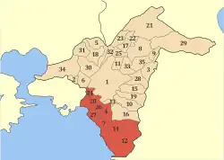
As a part of the 2011 Kallikratis government reform, the regional unit South Athens was created out of part of the former Athens Prefecture. It is subdivided into 8 municipalities. These are (number as in the map in the infobox):[1]
- Agios Dimitrios (4)
- Alimos (7)
- Elliniko-Argyroupoli (14)
- Glyfada (12)
- Kallithea (20)
- Moschato-Tavros (24)
- Nea Smyrni (26)
- Palaio Faliro (27)
See also
References
Administrative division of the Attica Region | ||
|---|---|---|
| Regional unit of Central Athens | 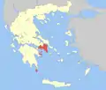 | |
| Regional unit of North Athens | ||
| Regional unit of West Athens | ||
| Regional unit of South Athens | ||
| Regional unit of Piraeus | ||
| Regional unit of East Attica | ||
| Regional unit of West Attica | ||
| Regional unit of Islands | ||
| ||
This article is issued from Wikipedia. The text is licensed under Creative Commons - Attribution - Sharealike. Additional terms may apply for the media files.