| Skerne | |
|---|---|
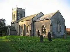 Saint Leonard's Church, Skerne | |
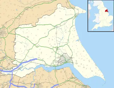 Skerne Location within the East Riding of Yorkshire | |
| OS grid reference | TA045552 |
| • London | 170 mi (270 km) S |
| Civil parish | |
| Unitary authority | |
| Ceremonial county | |
| Region | |
| Country | England |
| Sovereign state | United Kingdom |
| Post town | DRIFFIELD |
| Postcode district | YO25 |
| Dialling code | 01377 |
| Police | Humberside |
| Fire | Humberside |
| Ambulance | Yorkshire |
| UK Parliament | |
Skerne is a village and former civil parish, now in the parish of Skerne and Wansford, in the East Riding of Yorkshire, England. The village is situated 1 mile (1.6 km) to the south of the River Hull and the Driffield Canal. It is approximately 2 miles (3 km) south-east from Driffield and 2 miles north-east from Hutton Cranswick.
Skerne Grade I listed Anglican church is dedicated to St Leonard.[1] The church is substantially Norman, particularly the nave, chancel and south doorway. The north aisle is 13th-century. The Perpendicular tower is ashlar faced. Three interior effigies, possibly, according to Pevsner, 12th- or 13th-century, are opposite the church door: a cross-legged knight holding a small shield, a woman shown within a quatrefoil, and between these a baby.[2]
In 1823 Skerne inhabitants numbered 251. Occupations included eleven farmers, a tailor, a flax dresser who was also a corn miller, and the landlord of the Board public house.[3]
Skerne public house, The Eagle, closed in 2004.[4] It was one of only 11 left in the UK without a bar counter, and served beer through a set of cash register handpulls. Prior to that beer was drawn directly from the barrels in the cellar and brought up in enamel jugs[5] [4] Planning permission was granted in 2011 for conversion to residential usage.[6] The Eagle is Grade II listed by Historic England.[4][6][7]
Governance
On 1 April 1935 the parish of Wansford was merged with Skerne,[8] on 9 March 1979 the merged parish was renamed "Skerne & Wansford".[9] In 1931 the parish of Skerne (prior to the merge) had a population of 203.[10]
References
- ↑ Historic England. "Church of St Leonard (1084138)". National Heritage List for England. Retrieved 4 December 2011.
- ↑ Pevsner, Nikolaus; The Buildings of England. Yorkshire: York and the East Riding pp. 339, 340; Penguin (1972); reprinted 1975, Pevsner Architectural Guides. ISBN 0-14-071043-4
- ↑ Baines, Edward (1823). History, Directory & Gazetteer of the County of York. p. 388. ISBN 1230139141.
- 1 2 3 "Objectors swoop on pub to house plan". Driffield Times & Post. 31 August 2011. Retrieved 17 April 2012.
- ↑ personal recollection from 1980
- 1 2 "Green light for pub conversion". Driffield Times & Post. 10 September 2011. Retrieved 17 April 2012.
- ↑ Historic England. "The Eagle (1391423)". National Heritage List for England. Retrieved 18 June 2015.
- ↑ "Relationships and changes Skerne CP/AP through time". A Vision of Britain through Time. Retrieved 12 August 2023.
- ↑ "Bridlington Registration District". UKBMD. Retrieved 12 August 2023.
- ↑ "Population statistics Skerne CP/AP through time". A Vision of Britain through Time. Retrieved 12 August 2023.
- Gazetteer — A–Z of Towns Villages and Hamlets. East Riding of Yorkshire Council. 2006. p. 10.
External links
![]() Media related to Skerne at Wikimedia Commons
Media related to Skerne at Wikimedia Commons
- "Skerne: Geographical and Historical information from the year 1892." (Bulmers'), Genuki.org.uk. Retrieved 16 April 2012
- Skerne in the Domesday Book
| Unitary authorities | |
|---|---|
| Major settlements (cities in italics) | |
| Rivers | |
| Canals | |
| Topics | |