Sieghartskirchen | |
|---|---|
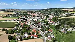 South view of Sieghartskirchen | |
 Coat of arms | |
 Sieghartskirchen Location within Austria | |
| Coordinates: 48°15′14″N 16°00′45″E / 48.25389°N 16.01250°E | |
| Country | Austria |
| State | Lower Austria |
| District | Tulln |
| Government | |
| • Mayor | Josefa Geiger (ÖVP) |
| Area | |
| • Total | 61.68 km2 (23.81 sq mi) |
| Elevation | 205 m (673 ft) |
| Population (2018-01-01)[2] | |
| • Total | 7,528 |
| • Density | 120/km2 (320/sq mi) |
| Time zone | UTC+1 (CET) |
| • Summer (DST) | UTC+2 (CEST) |
| Postal code | 3443 |
| Area code | 02274 |
| Vehicle registration | TU |
| Website | www.sieghartskirchen.gv.at |
Sieghartskirchen is a municipality in the district of Tulln in the Austrian state of Lower Austria.
Population
| Year | Pop. | ±% |
|---|---|---|
| 1869 | 4,353 | — |
| 1961 | 4,007 | −7.9% |
| 1991 | 5,812 | +45.0% |
| 2001 | 6,674 | +14.8% |
| 2010 | 7,011 | +5.0% |
References
- ↑ "Dauersiedlungsraum der Gemeinden Politischen Bezirke und Bundesländer - Gebietsstand 1.1.2018". Statistics Austria. Retrieved 10 March 2019.
- ↑ "Einwohnerzahl 1.1.2018 nach Gemeinden mit Status, Gebietsstand 1.1.2018". Statistics Austria. Retrieved 9 March 2019.
.JPG.webp)
Parish church
Wikimedia Commons has media related to Sieghartskirchen.
This article is issued from Wikipedia. The text is licensed under Creative Commons - Attribution - Sharealike. Additional terms may apply for the media files.