Shirabad
Persian: شورآباد | |
|---|---|
Village | |
 Shirabad | |
| Coordinates: 28°21′18″N 60°28′24″E / 28.35500°N 60.47333°E[1] | |
| Country | |
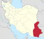
| Province | Sistan and Baluchestan |
| County | Taftan |
| District | Gowhar Kuh |
| Rural District | Shirabad |
| Population (2016)[2] | |
| • Total | 751 |
| Time zone | UTC+3:30 (IRST) |
Shirabad (Persian: شورآباد) is a village in Shirabad Rural District of Gowhar Kuh District, Taftan County, Sistan and Baluchestan province, Iran, and serves as capital of the district.[3]
At the 2006 National Census, its population was 693 in 148 households, when it was in Gowhar Kuh Rural District of the former Nukabad District of Khash County.[4] The following census in 2011 counted 525 people in 114 households.[5] The latest census in 2016 showed a population of 751 people in 267 households; it was the largest village in its rural district.[2]
In 2019, the district was separated from the county in the establishment of Taftan County, which was divided into three districts of two rural districts each, with Nukabad as its capital and only city.[3]
References
- ↑ OpenStreetMap contributors (20 April 2023). "Shirabad, Taftan County" (Map). OpenStreetMap. Retrieved 20 April 2023.
- 1 2 "Census of the Islamic Republic of Iran, 1395 (2016)". AMAR (in Persian). The Statistical Center of Iran. p. 11. Archived from the original (Excel) on 23 December 2021. Retrieved 19 December 2022.
- 1 2 Raisi, Elham (14 December 2019). "Creation of Taftan County in Sistan and Baluchestan province". Iranian Students' News Agency (in Persian). Government Printing Board. Archived from the original on 15 December 2019. Retrieved 20 April 2023.
- ↑ "Census of the Islamic Republic of Iran, 1385 (2006)". AMAR (in Persian). The Statistical Center of Iran. p. 11. Archived from the original (Excel) on 20 September 2011. Retrieved 25 September 2022.
- ↑ "Census of the Islamic Republic of Iran, 1390 (2011)" (Excel). Iran Data Portal (in Persian). The Statistical Center of Iran. p. 11. Retrieved 19 December 2022.