| Sgurr Dhòmhnuill (mountain) | |
|---|---|
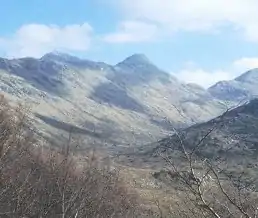 Looking up Strontian Glen towards Sgurr Dhòmhnuill | |
| Highest point | |
| Elevation | 888 m (2,913 ft) |
| Prominence | c. 873 m Ranked 17th in British Isles |
| Parent peak | Carn Eige |
| Listing | Corbett, Marilyn |
| Naming | |
| English translation | Donald's rocky peak |
| Language of name | Gaelic |
| Pronunciation | Scottish Gaelic: [ˈs̪kuːɾ ˈɣɔ͂ː.ɪʎ] |
| Geography | |
| Location | Ardgour, Scotland |
| OS grid | NM889678 |
| Topo map | OS Landranger 40 |
Sgurr Dhòmhnuill or Sgurr Dhòmhnaill is a mountain in western Scotland. The summit lies about ten kilometres (six miles) northeast of Strontian.
56°45′14″N 5°27′17″W / 56.75386°N 5.45461°W
| Northern Highlands (20) |    | |
|---|---|---|
| Western Highlands (20) | ||
| Central and Eastern Highlands (13) | ||
| Southern Highlands (15) | ||
| Islands (13) | ||
| Scottish Lowlands, England and Wales (13) | ||
| Republic of Ireland, Northern Ireland (25) | ||
This article is issued from Wikipedia. The text is licensed under Creative Commons - Attribution - Sharealike. Additional terms may apply for the media files.